Ana Ferreira on Seeing Flows in the Mantle
Listen to the podcast here or wherever you listen to podcasts.
-
Note, transcripts are not fully edited for grammar or spelling.
Oliver Strimpel: This is Geology Bites with Oliver Strimpel. In 1919, the great British geologist Sir Arthur Holmes suggested that continental drift was driven by convection in the Earth's mantle. He proposed that lateral movement at the top of convection cells in the mantle would propel the crust sideways, with the continents essentially riding on top of a mantle conveyor belt. More recently, with the advent of plate tectonic theory, the majority view is that the main force that acts on the lithospheric plates is the pull from slabs of cold, dense, oceanic lithosphere sinking into the mantle at subduction zones. This presents an apparent dichotomy. Do upper mantle convection cells drive plate tectonics, or is it primarily the negative buoyancy of subducting slabs that provide the motive force? The answer to this question is elusive, not least because it's hard to observe what's going on in the mantle or deep in subduction zones. The principal source of evidence as to what is happening at depth comes from seismology, and seismological techniques have been advancing at ever more rapid pace, driven both by improved seismic data collection around the world and ever more sophisticated modelling and numerical analysis. Anna Ferreira is one of the seismologists at the forefront of this research. She is Professor of Seismology in the Department of Earth Sciences at University College London. Ana Ferreira, welcome to Geology Bites.
Ana Ferreira: Thank you for the invitation, Oliver. It's a real pleasure and honor to be here.
Oliver Strimpel: Can we start by refreshing ourselves on some fundamentals of seismology? What sort of seismic waves do you look at and where do they come from?
Ana Ferreira: Seismology studies seismic wave propagation inside the Earth. So earthquakes occur every day, and they generate many different types of waves. For example, body waves, P&S waves that propagate deep inside the earth. They also generate surface waves that the name indicates propagate along the surface of the Earth. All of these different waves travel and probe different regions of the Earth's interior, and so, as a seismologist, I really combine all of these different types of waves to start to then build comprehensive images of the interior of our planet.
Oliver Strimpel: When you say you build an image, are you basically looking at the arrival times of seismic waves as they travel through the earth and using that information to tell you something about the interior?
Ana Ferreira: Exactly! So we measured the arrival times of waves, but actually we even go further. We measure the amplitudes as well, and sometimes we even use the full waveforms by using these recordings at the Earth’s surface — arrival times, amplitudes, actual waveforms. We really try to see what is inside the Earth, pretty much like medical imaging. When we go to, say, a CAT scan in a hospital. It's the same sort of concept.
Oliver Strimpel: So your work depends critically on a particular aspect of seismic waves, which is that of anisotropy. What is seismic anisotropy?
Ana Ferreira: Seismic anisotropy is the directional dependency of seismic wave speed. It tells us if seismic waves propagate faster in one direction or in a different direction. And in my particular case, I have been working on a very specific type of anisotropy, which is the simplest type of anisotropy, and this is so-called radial anisotropy, which is the difference between vertically and horizontally polarized seismic waves. Or, in other words, by imaging radial anisotropy, we can really identify whether a given seismic wave will travel faster in the vertical or on the horizontal direction.
Oliver Strimpel: By vertical, you mean radial up and down, and horizontal means sort of tangential to the Earth.
Ana Ferreira: Exactly, yes.
Oliver Strimpel: What causes anisotropy in seismic waves?
Ana Ferreira: The main mechanism that is thought to cause anisotropy is a so-called lattice preferred orientation, whereby minerals in the Earth's mantle, such as olivine, which is the dominant mineral in the Earth's mantle, minerals that are intrinsically anisotropic, they might get aligned by deformation. For example, due to mantle flow. Which then leads, because of this alignment of all these different minerals, it leads to macroscopic seismic, observable anisotropy. And so, by observing the anisotropy using our seismic data, we can do the reverse exercise of inferring the directions of the mantle flow that has caused it.
Oliver Strimpel: I'm reminded of David Bercovici's podcast, in which he talked about a very similar lattice preferred orientation caused by shear deformation in the Pacific Plate. But, of course, here you're talking about deformation, not within the plate, but in the mantle at depths an order of magnitude greater, about a 1000 kilometers down.
Ana Ferreira: Exactly! Now this is the so-called intrinsic anisotropy. The complication is that there are actually other factors that can also lead to anisotropy, and also so-called apparent anisotropy, which is, for example, when we have big contrasts in isotropic seismic velocities in the mantle. And this is the case when we have, say, pockets of melts in the mantle that are aligned. These pockets of melt have much lower velocities than the surrounding mantle, and alignment of these pockets with very different velocities can then lead to these so-called apparent anisotropies. So when we observe it with our seismic data, we always need to be very careful to interpret what we are observing and to distinguish the different mechanisms that may be responsible.
Oliver Strimpel: Just to come back to the intrinsic anisotropy for a moment, when you say olivine is an intrinsically anisotropic mineral, do you mean like the physical shape of the olivine grain in the mantle?
Ana Ferreira: Yes, exactly its shape and its properties. So if you have a single crystal of olivine, there are preferential directions in terms of seismic wave speeds. One direction being much faster than the other.
Oliver Strimpel: And when you say you can tell something about the mantle from this. Is it because the actual olivine crystals get physically aligned, say, with a long axis along the flow?
Ana Ferreira: That's exactly the process. So all of these crystals that might be randomly distributed, they get aligned by the mantle flow leading to this macroscopic observation. So because with our seismic data we can't really see microscopic processes, all that we see is really macroscopic. So we really need a substantial deformation to align the individual crystals to then lead to observable macroscopic anisotropy.
Oliver Strimpel: So basically speaking, the more anisotropy, the more flow or deformation or alignment of the crystals we are seeing.
Ana Ferreira: Exactly!
Oliver Strimpel: In several previous podcasts, such as the ones with Barbara Romanowicz and Alan McNamara, we discussed seismic tomography, which you've alluded to, in which techniques similar to medical tomography are used to build 3D images of the seismic wave speed in the Earth's interior. Is seismic anisotropy essentially another data type that can be layered on top of these tomographic images of wave speed?
Ana Ferreira: Seismic anisotropy is not really data. Seismic anisotropy is a physical property of the Earth’s interior, and so it's actually another level of tomography, if you want. So the most widely known and most common tomography is imaging seismic wave speeds. So that's the 1st order property that our seismic data are sensitive to. Anisotropy is beyond, if you want a seismic wave speed, and it's very important because it really can tell us more about mantle flow, as I've just explained, which seismic waves speeds per se don't really directly say so much, and so it's going beyond on the physics. And so the data that we use might still be the same. But the big challenge is that our seismic data are less sensitive to anisotropy than seismic wave speeds. And so we have to use more data. We have to use, in particular, data that are sensitive to both horizontally and vertically polarized waves. So we need more data, but also more complementary data than with the same standard tomography analysis. And we need to be more advanced in terms of the modeling to extract this information from the data.
Oliver Strimpel: But to get the spatial distribution of this flow, you are essentially folding the anisotropy data into a sort of tomographic inversion.
Ana Ferreira: Yeah, exactly. You know, another way of saying it is that when you study anisotropy, you have many more parameters that you need to constrain, like your images have more information.
Oliver Strimpel: Where do you get your seismic data from?
Ana Ferreira: Seismology is really a data-rich discipline, and we are very, very lucky that we have something that is called the global seismic network. It's a network of over 100 seismic stations that are continuously recording ground motions, and these data are very, very carefully quality controlled. And then they are freely distributed to anyone, to anyone who wants to use them. And this is really extraordinary and it's really only possible due to coordinated efforts of many countries worldwide, and also seismologists worldwide, who make the effort to collect the data, to analyze and quality-control the data and distribute it in a freely available way. So I always like to talk about the global seismic network because I don't think it's something that exists in so many different fields. It's really an absolutely beautiful example of altruistic international collaboration. Just giving the data in almost real time. And so that's mostly where my data come from.
Oliver Strimpel: So I could go to some website and tap into the data myself.
Ana Ferreira: Exactly, anyone.
Oliver Strimpel: Wow. Amazing.
Ana Ferreira: Yes
Oliver Strimpel: So this is a global network. So are you trying to infer the dynamics of the mantle on a global scale?
Ana Ferreira: So actually, my work is indeed done at the global scale. And indeed, my ultimate goal, my dream, if you want, is indeed to try to constrain the patterns of mantle flow at the global scale. But so far, the work that we have been doing has been actually mostly focusing on some specific regions. In particular, we have looked a lot at subduction zones. So these are regions where these old cold material plunges inside the Earth, like in the Western Pacific. We're talking Japan, the Philippine Sea, and also a specific region where we have looked in detail at the dynamics and the patterns of mantle flow using our anisotropy images. It's in the Tonga Kermadec region where we seem to have observed a very exciting interaction between the Tonga slab going down, dipping inside the Earth, and the Samoa plume. So this very large-scale material, hot material coming up all the way from about 3,000 kilometers depth and interacting with the slab.
Oliver Strimpel: Wow, that's interesting. So actually, in a recent podcast, Matt Jackson spoke about the hot spots in the South and West Pacific, including the Samoa hotspot that you just mentioned, but mainly with respect to their distinctive compositions rather than their dynamics. Although he did note that it seemed like, even though there were different hotspots quite close, that their chemical sources seem to be quite distinct over millions and millions of years. But what have you observed in this region?
Ana Ferreira: When we started building our images of global anisotropy, one thing that really popped out was this very, very distinct and strong anisotropy anomaly in the Tonga region and quite deep, so at about 1,000 kilometers depth. And obviously the first thought that you have is all these must be some artifact. We must have done something wrong in the construction of our images. So we've done lots of tests to check that there aren't artifacts, that there are real features, and we really got very confident on these observed anomalies. And so then we went into trying to understand what does this anomaly mean in our images? And it turns out that the Tonga-Kermadec system, so it's a subduction zone as I was saying, so you have a cold old material plunging inside the Earth. It's complex, and in the Tonga region, which is in the northern part of the system, this slab at about 600 kilometers depth, which is the boundary between the upper and the lower mantle, it sort of stagnates. It becomes horizontal, whereas further south in Kermadec it goes all the way down into the lower mantle. So that's an interesting observation. And the other observation is that the slab in the Tonga part at the surface it retreats really very fast. It's one of the fastest retreating slabs on Earth, and this is not so much observed in Kermadec. So we have these very strong and isotropy anomalies, so suggesting very strong deformation happening in the deep mantle. And in the isotropic images we saw the slab, but we also saw this low-velocity anomaly which suggested warm material coming all the way from the core-mantle boundary, which really matched quite nicely with the Samoa hotspot. And so really suggesting that it's the Samoa plume. And we really saw the two anomalies, the slab and the plume really very closely interact with each other. And so our hypothesis was that this strong deformation that we are seeing actually corresponds to a deep collision of the plume upwelling with the downwelling with the slab. But, as well, what we suggested is that maybe the plume is actually contributing to the slab to become horizontal. And so we worked with the geodynamicists who did some simulations and did find that yes, physically this is a plausible scenario. So we could infer that deep in the mantle the flow was mostly horizontal. We really see the ponding of the plume and then further up in the upper mantle it became vertical with the plume going around the slab, so this was really obviously very exciting for us.
Oliver Strimpel: Wow, that's amazing. So you're actually witnessing plume - slab interaction at a really fine scale.
Ana Ferreira: Still large scale, but we can see it because we are talking about a very big plume, and the slab is also quite a big object. But yes, the level of detail is quite extraordinary.
Oliver Strimpel: Well, of course, we put the images that show this on the episode web page. But what kind of resolution, then, do you have in these images?
Ana Ferreira: We are really still talking about resolutions of about 1,000 kilometers, so it's very coarse.
Oliver Strimpel: So if I were to try and simplify it, what you're seeing is that maybe the slab is forcing the plume to flow around it, and the plume is pushing on the slab to make it subduct in a flatter direction than it otherwise would.
Ana Ferreira: Yeah, there's an extra element which is the fact that further south in Kermadec, this Kermadec slab going down, it has a plateau attached to it. So a block of material called the Hikurangi plateau. And what we found is that the plateau actually has a role as well. So there's a coupled effect of the plume and that plateau that leads to this fast retreat of the slab at the surface, which then has a positive feedback accentuating the flattening of the slab at depths. So it's really the two who play roles. So both the plume, but as well the plateau.
Oliver Strimpel: Have you studied any other regions to look for plume - slab interaction?
Ana Ferreira: We didn't find such strong signals elsewhere, but there have been in the literature some suggestions that maybe there are also plume-slab interactions in Yellowstone. The challenge there is that the Yellowstone plume, if it is a plume, it's still debated, it's a very thin plume. And so then we are at the limits of resolution in our seismic imaging. But that would be a candidate. We can also speculate that there are many, many fast-retreating slabs on Earth. And so maybe there are small fine upwellings nearby where these type of interactions happen as well. But as I said, our resolution is still limited. But it's definitely something to look for in the future as we get more and more data and as we get more advanced algorithms to sharpen our images.
Oliver Strimpel: So your basic idea here is that the sort of dynamics of slabs, including the angle at which they subduct or flatten, or the rate at which they retreat, might be a consequence of some interaction with the plume in the neighborhood.
Ana Ferreira: Exactly. That's our hypothesis.
Oliver Strimpel: Is it possible to do meaningful simulations of plume - slab interactions in an analog form in physical lab experiments?
Ana Ferreira: When we were interpreting our results, obviously we looked in the literature, and we could find some very nice examples precisely of laboratory experiments of plume - slab interactions in the context of Yellowstone, but actually also in the context of Tonga and Samoa. They were focusing mostly in the shallower mantle, not as deep as us, like this 1,000 kilometers depth region that I was mentioning. But the upper mantle part of our image is really matched very nicely by what had been observed in this laboratory experiment. So that's other evidence confirming our interpretation.
Oliver Strimpel: What kind of materials can you use as analogs in a tank in the lab?
Ana Ferreira: So you probably will be surprised, but things like sugar syrup. So if you want to simulate a plume, it's very common to have a tank filled with sugar syrup that then you'll hit from beneath and you start getting these instabilities.
Oliver Strimpel: So does this close interaction between plumes and slabs that you've revealed cast light on the question I raised in my introduction, namely, what is the primary driver of plate tectonics?
Ana Ferreira: Really, one of the main messages that we got from this particular study in the Tonga region is that mantle plumes really seem to be more dynamic than previously thought. So the traditional view is that convection might be driven mainly by slabs and plumes maybe are more not so dynamic features just being deviated by slabs. But our work suggests that they can be very dynamic, and they can even change the behavior of slabs. And there are even some simulations and lab experiments from geodynamics that even suggest that plumes might even contribute to initiate subduction. So they definitely seem to be not these passive features. And so we really need to see plates and plumes as really part of one system, of one mantle convection system. Rather than this dichotomy of convection driving plates and so on.
Oliver Strimpel: That's interesting. So really, it's a false dichotomy you're saying.
Ana Ferreira: I wouldn't go as far as saying that it's false. It's a model, and our current model is more that the whole system interacts and has feedbacks, and we should see plates as being an integral part of convection, of mantle convection rather than being a separate feature.
Oliver Strimpel: OK, so from what you've described, it certainly seems that convective upwellings in the mantle are much more chaotic than the regular large-scale mantle convection cells envisaged by Arthur Holmes. But at the end of the day, would you still say that slab pull from subducting oceanic lithosphere is still likely to be the main driving force of plate motions?
Ana Ferreira: Yes, slab pull is still thought to be the main driving force of plate motions, but convection is driven both by top-down subduction as in the traditional view, but also by bottom-up forces, particularly by these mantle upwellings, mantle plumes that result from heat and instabilities occurring across the core – mantle boundary. This mantle upwelling effect is being considered more and more important.
Oliver Strimpel: What are you working on at the moment?
Ana Ferreira: As I mentioned, I work globally, but in terms of interpretation, the patterns of flow we have focused a lot on subduction zones. And then we had this nice work on slab - plume interaction. But now we are really moving more into actual upwelling mantle plumes and just general upwellings, which are less well understood. And also the imaging is more challenging, and that's in part because a lot of upwellings occur beneath the oceans. And as I mentioned before, we have this beautiful global seismic network with stations all over the world, but obviously within the continents. There are more and more temporary seismic experiments in the ocean, so we are starting to have more data, but it's still the biggest gap in terms of data coverage in our planet. So I've been awarded a project from the European Research Council called UPFLOW. My goal is to better understand upward mantle flow. There are two main aspects. One is to develop new seismic imaging techniques to sharpen our tomographic images, and the other one is to have new data. And last summer, we conducted an experiment in the Azores Madeira Canary Islands region, a massive region where we deployed 50 ocean-bottom seismometers. So instruments in the sea floor that are hopefully quietly recording right now as we speak. We will collect them in the summer, and with this new data, we really hope to be able to improve our resolution, at least in the upper mantle, from this 1,000 kilometers resolution that I was talking before, hopefully it would scale as like 100 kilometers.
Oliver Strimpel: Wow, tenfold improvement would be quite dramatic. You could really resolve the individual plumes, I guess.
Ana Ferreira: Yes, this is our goal, and this system is particularly interesting because we have upwellings beneath the Canary Islands. It's also actually very active right now in the La Palma eruption. We have the Azores, which is a very interesting region as well, because there's a triple junction, a ridge. So new material is coming up. But there have been suggestions as well there's not only the shallow upwelling, but also a deeper upwelling, possibly from the lower mantle. Still an open question. And there's also Madeira in the region, and we really don't know exactly if and how these different regions the upwellings in these regions interact, and as well if there are connections even with the bottom of the mantle. It's really the first time that we are covering a region with these multiple upwellings, and we are really keen to understand their interactions.
Oliver Strimpel: Ana Ferrera, thank you very much.
Ana Ferreira: Thank you, Oliver. It was a pleasure. Thank you so much.
Oliver Strimpel: If you're enjoying this series, I'd be grateful if you could rate the podcast and leave a review.
Scroll down for podcast illustrations.

Ana Ferreira is Professor of Seismology at University College, London. She collects and analyzes seismic data from around the world, focusing particularly on the anisotropy of seismic wave speeds, i.e., the variations in the speeds of differently polarized seismic waves. As she explains in the podcast, we can use observed anisotropy to infer alignment of crystals in the mantle, which in turn can reveal flow patterns in the mantle. She has new results that show how mantle plumes and subducting slabs can have a major effect on each other.
Podcast Illustrations
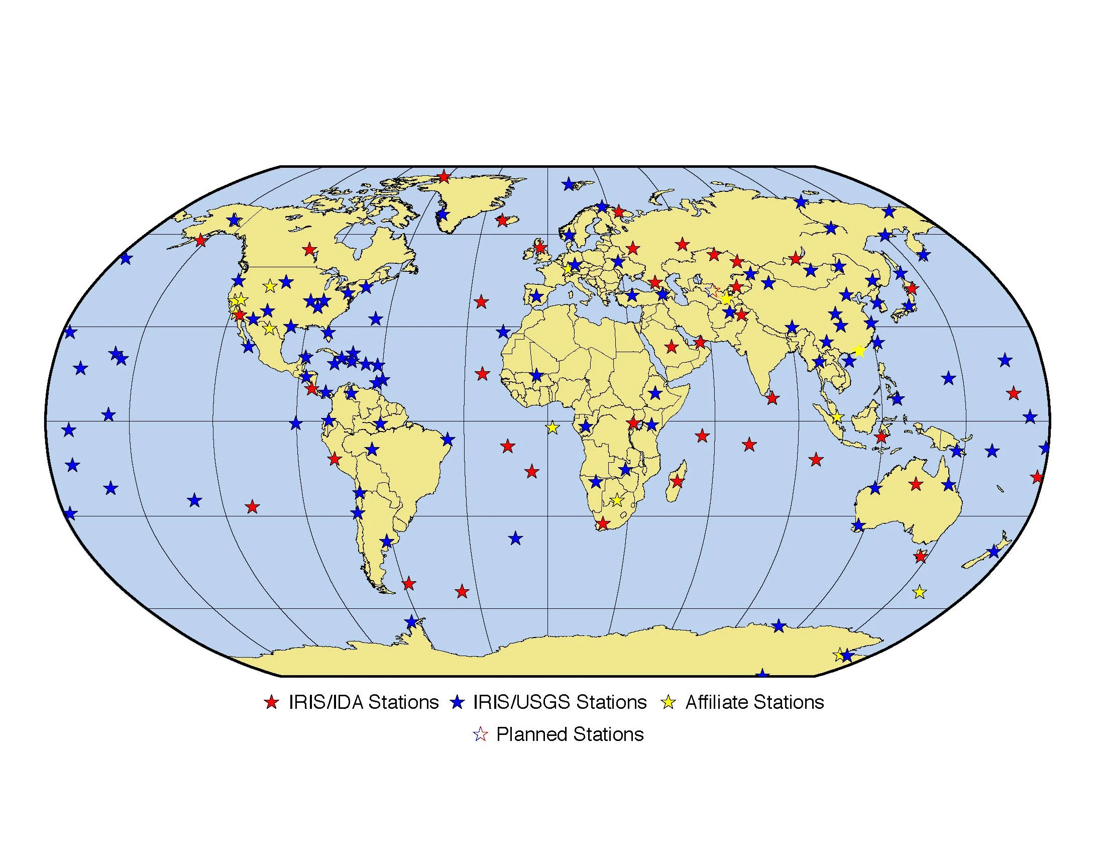
The Global Seismographic Network (GSN) is a 152-station, globally distributed, state-of-the-art digital seismic network that provides free, real-time, open access data. The map shows the distribution of the stations that contribute to the network. All the sensors are land-based. So far, Ana Ferreira has obtained her seismic data from GSN, but is now collecting data from ocean-based sensors in the area around the Canary Islands and the Azores.
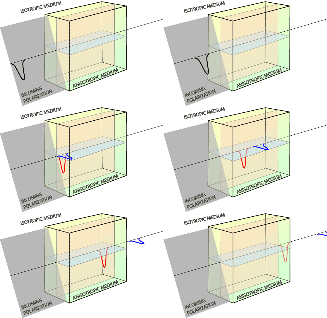
The splitting of seismic shear waves in anisotropic media. In an isotropic medium, all waves travel at the same speed, but in an anisotropic medium, the wave speed depends on the plane of polarization of the wave. By measuring the dispersion of arrival times of differently polarized shear waves emanating from a given earthquake, it is possible to perform an inversion and infer the location of anisotropic regions in the mantle and their degree of anisotropy.
Courtesy of Ed Garnero
Seeing Plume-Slab Interaction in the southwest Pacific
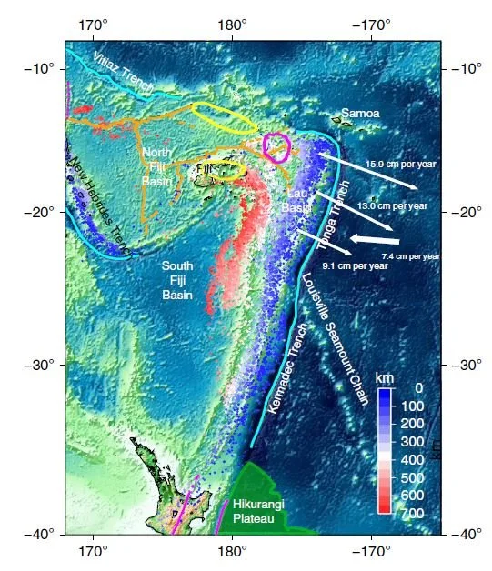
Bathymetry map of the region in the western Pacific where the Tonga-Kermadec trenches and the Samoan plume are located. The foci of earthquakes are shown as very small colored circles, which are coded according to their depth. Orange and cyan lines represent ridges and trenches, respectively. Regions that have the geochemical signature of the Samoan plume lie within the regions delineated by the magenta and yellow lines. The northern half of New Zealand’s North Island appears in the southwest part of the map.
Chang, S-J, Ferreira, A, & Faccenda, M (2016), Nature Communications 7:10 799
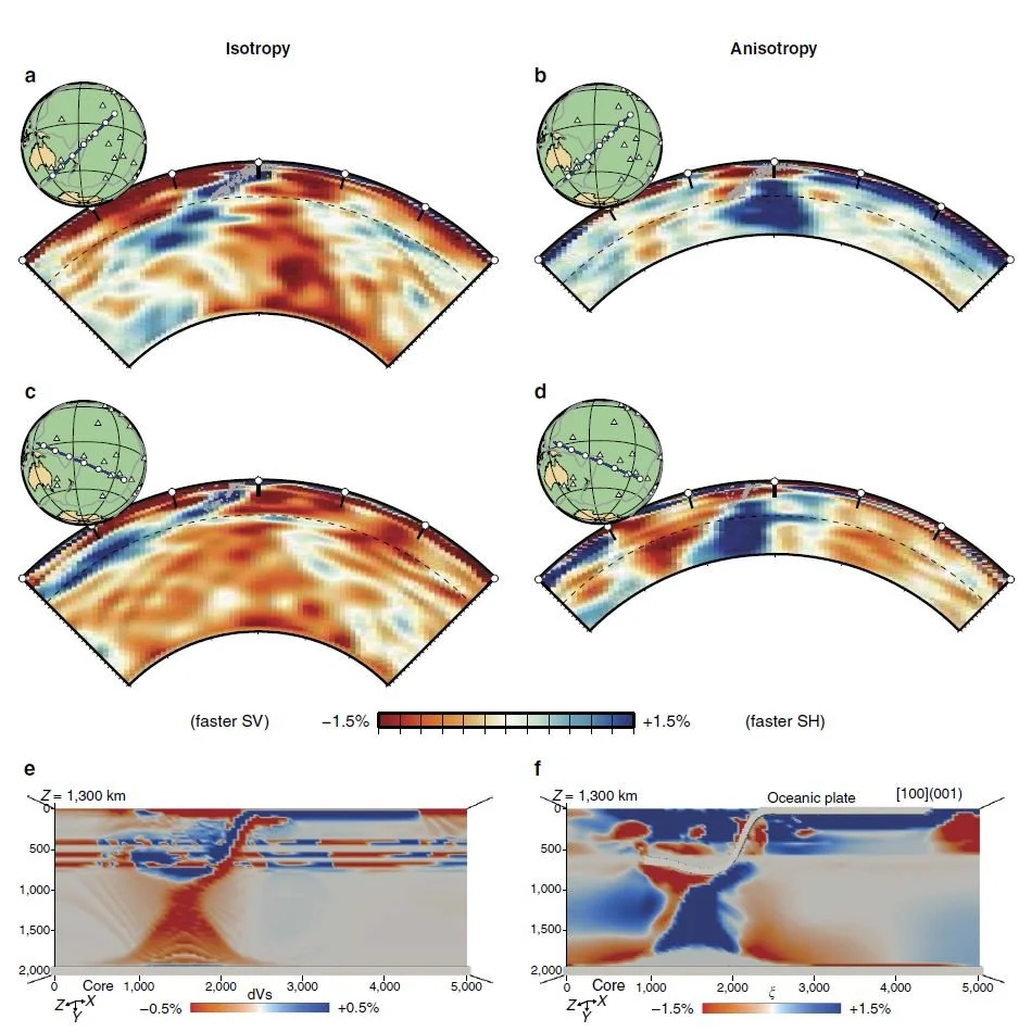
Seismic tomography of the southwestern region of the Pacific containing the Tonga-Kermadec trench and the Samoan plume. (a, c) Vertical cross sections along the SW-NE and NW-SE directions, respectively. The images show the wave speeds for vertical shear waves, with the large reddish (slow seismic wave speed) region, especially visible in (a), indicating the hot Samoan plume, and the blue (fast wave speed) regions indicating the cooler subducting Tonga slab. (b, d) Cross sections showing seismic anisotropy down to a depth of 1,400 km, which is the maximum depth at which the anisotropy is resolvable in the data. The sections show a distinct region of anisotropy (blue) behind the Tonga slab where the horizontal wave speed is ~2% greater than the vertical wave speed. This is interpreted as mantle flow induced by the subducting slab. (e, f) Seismic wave speed (e) and anisotropy (f) from geodynamic modelling of the subducting oceanic plate, the Hikurangi Plateau, and the Samoan plume, all of which are shown in the map above. The model appears to match the observations qualitatively, and suggests that the Samoa plume is a large upwelling originating from the core-mantle boundary. When this plume reaches the slab, it appears to flatten it, causing the subduction to stagnate. The pronounced signature in the seismic anisotropy seen in (b), (d), and (f) and the clear interaction between the Tonga slab (blue) and the Samoa plume (red/orange) seen in (c) may be revealing the interaction of the plume with the subducting plate. The transition between the upper and lower mantle at a depth of 660 km is indicated by the dashed line.
Chang, S-J, Ferreira, A, & Faccenda, M (2016), Nature Communications 7:10 799
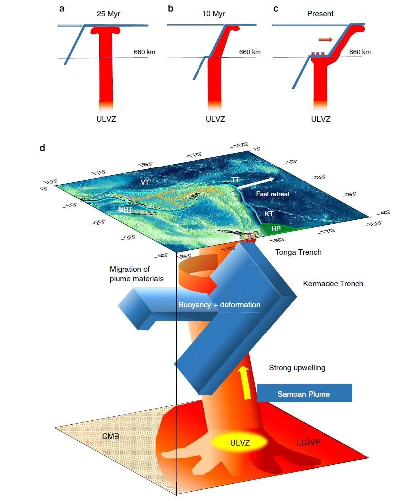
Illustration of the temporal evolution of the interaction between the Samoan plume and the Tonga-Kermadec slab. (a) The Samoan plume is generated at a large ultra-low-velocity zone (ULVZ) at the core-mantle boundary (CMB) and ascends to the surface. (b) The Samoan plume collides with the Tonga slab at the mantle transition zone about 10 million years ago. (c) The upward stress caused by the collision between the slab and the plume causes the slab to stagnate as well as intense seismicity (cross marks), which is further enhanced by fast slab retreat (red arrow) due to the subduction of the Hikurangi plateau. (d) A schematic diagram showing the slab-plume interaction beneath the Tonga-Kermadec volcanic arc. Cyan lines on the surface show trenches, as shown in the bathymetry map above. The Samoan plume originates from a large ULVZ within the south Pacific large low-shear-velocity province (LLSVP) at the CMB. The buoyancy caused by upward stress from the plume below the Tonga slab may contribute to the slab stagnation within the mantle transition zone, while the Kermadec slab penetrates into the lower mantle. At the northern end of the Tonga slab, plume material migrates into the mantle wedge via toroidal flow around the slab edge induced by fast slab retreat. HP, Hikurangi Plateau; KT, Kermadec Trench; TT, Tonga Trench.
Chang, S-J, Ferreira, A, & Faccenda, M (2016), Nature Communications 7:10 799
Further reading
UPFLOW - upward mantle flow from novel seismic observations: https://upflow-eu.github.io/
Chang, S-J., Ferreira, A.M.G., Ritsema, J., van Heijst, H.J., Woodhouse, J.H. (2015) Joint inversion for global isotropic and radially anisotropic mantle structure including crustal thickness perturbations, Journal of Geophysical Research: Solid Earth, 120 (6), 4278-4300. doi:10.1002/2014jb011824
Chang, S.-.J., Ferreira, A.M.G., Ritsema, J., van Heijst, H.J., Woodhouse, J.H. (2014), Global radially anisotropic mantle structure from multiple datasets: A review, current challenges, and outlook, Tectonophysics, 617 1-19. doi:10.1016/j.tecto.2014.01.033
Ferreira, A. M. G., Faccenda, M., Sturgeon, W., Chang, S.-.J., Schardong, L. (2019) Ubiquitous lower-mantle anisotropy beneath subduction zones, Nature Geoscience, doi:10.1038/s41561-019-0325-7