
Gillian Foulger on Explaining Intraplate Volcanism Without Mantle Plumes

Gillian Foulger is Emerita Professor of Geophysics at Durham University. She points out the lack of evidence in support of the mantle plume hypothesis and describes an alternative - the plate hypothesis. A key prediction of the plate hypothesis is that the lithosphere should be extending wherever we see intra-plate volcanism. She explains that many of the observations we already have can be reinterpreted as consistent with the plate hypothesis, and suggests new experiments that could clearly distinguish the competing hypotheses.
Listen to the podcast here or wherever you listen to podcasts.
Scroll down for illustrations that support the podcast. And add your comments at the bottom of the page.
Note - playing the podcast is not supported on Internet Explorer; please use any other browser, or listen on Spotify, Apple Podcasts, etc.
-
This transcript was generated automatically and lightly edited for readability.
Oliver Strimpel: This is Geology Bites with Oliver Strimpel. After a decade of vigorous debate, the mantle plume hypothesis, first proposed in a paper by Jason Morgan in 1971, became the widely accepted explanation for the existence of volcanoes located far away from plate boundaries. Plumes are posited to be upwellings of hotter-than-average mantle arising from a great depth, most probably from the very bottom of the mantle, where it meets the Earth's core. Hawaii and other mid-ocean islands are pointed to as the classic examples of plume-induced, or so-called hotspot, volcanoes. However, even as the plume hypothesis has become more and more entrenched, the evidence for them remains inconclusive. Even seismic tomography has yet to attain the resolution needed to detect them in the lower mantle.
Gillian Foulger is emeritus professor of geophysics at Durham University. She is a leading exponent of the plate theory for volcanism, in which the theory of plate tectonics is able to account for all of the Earth's volcanism, dispensing with the need for additional hypotheses, including mantle plumes. Gillian Foulger, welcome to Geology Bites.
Gillian Foulger: Thank you, Oliver, and thank you for doing this podcast.
Oliver Strimpel: Can you remind me what it was exactly that led Jason Morgan and others to propose the existence of mantle plumes?
Gillian Foulger: Well, during the '60s, when plate tectonics was developed, it became immediately clear to scientists that most volcanism on Earth was immediately explained as occurring at plate boundaries. Much of this was occurring along mid-ocean ridges, where the plates are moving apart, and some was occurring behind subduction zones, island arcs. But then there was Hawaii. It was smack in the middle of the biggest plate on Earth, and it was as far away from any plate boundary as you could possibly get anywhere on the surface of the Earth, and it's a huge and very productive cluster of volcanoes. So this was kind of a glaring exception to the general rule, and it needed some kind of explanation.
Oliver Strimpel: Did you espouse the mantle plume hypothesis when you started your career as a research geologist?
Gillian Foulger: Guilty, your honor. When I was an undergraduate and afterwards, it was presented to me by all my colleagues and teachers and mentors as though this was just a fact, as well established as plate tectonics, of which we were very confident, of course. But I never questioned the case for plumes. And in the first part of my teaching career, as a lecturer at Durham University, I taught the undergraduates the mantle plume hypothesis, and I taught them that the Hawaii-Emperor seamount chain bend was due to a change in the direction of the Pacific plate, and we all assumed that this was correct. It wasn't till I looked into it that I started to find that not everything was quite as clear and straightforward as we'd all been led to believe.
Oliver Strimpel: Was there something in particular that brought on your misgivings about the existence of plumes?
Gillian Foulger: What triggered me, really, and this was a kind of cathartic experience: I did a large seismic tomography experiment covering the whole of Iceland. I worked with Jason Morgan at Princeton in the USA. We covered the island of Iceland with very modern broadband seismic stations, and we gathered a lot of seismic data, and we performed an inversion to study the three-dimensional structure down to about 600 kilometers. And what we saw there wasn't consistent with what we expected a mantle plume to look like. So I took these results to an international conference in San Francisco in 1999, and I discussed them with colleagues there. And to one colleague I said, "Clearly, this mantle plume is different from what we expected; it's a different kind of mantle plume." And he said, "Well, maybe there isn't a mantle plume there." And I was completely poleaxed by this incredible suggestion. It had never occurred to me before that such a thing could be so. And I just started asking questions: What about this? What about that? What about the other? And that just led me into a 10-year-long roller coaster ride, where I realized that we had to just drop all these assumptions. We just hadn't been thinking about what we were doing. That was the conclusion that I came out with.
Oliver Strimpel: But surely since that 1990s Iceland study of yours, there have been a ton of other studies that support the existence of mantle plumes.
Gillian Foulger: There's a difference between being consistent with a hypothesis and requiring it. So many things could be claimed to be consistent with a mantle plume hypothesis. But on the other hand, if there are half a dozen other explanations, and you've had to change the plume hypothesis beyond all recognition to cram your foot into the glass slipper that wasn't made for it, then we have to really think about what we're doing.
Oliver Strimpel: So what exactly are the geological features that would provide conclusive evidence of the existence of a mantle plume?
Gillian Foulger: In the early days of the development of MantlePlumes.org, the website that really hosts the debate regarding the existence of mantle plumes, I thought it would be helpful to decide exactly what a mantle plume was, because there are so many different variants. So I reached out to Professor Ian Campbell of the Australian National University. Professor Campbell is well known for his work simulating plumes in large tanks full of fluid in his laboratory there. And I asked him what he considered the plume hypothesis to predict. What are the predictions? If we go to study an area, what should we look for, and what things should we expect to observe? A scientific hypothesis should be forward-predictive. He very obligingly clarified that in his view, there were five primary predictions that we should look for if we're testing for the existence of a mantle plume.
So the first one is that when the mantle plume first rises up through the mantle and reaches the base of the lithosphere, it domes the lithosphere up, so we should see kilometer-scale lithospheric uplift on a scale of some hundreds of kilometers broad. That's the first one. Following this uplift, we should see the outpouring of a flood basalt, for example the Deccan Traps, something like that. The third thing is that there should be a tail, a plume tail, stretching from the surface down to the core-mantle boundary, and hopefully we should be able to image this with methods such as seismic tomography. The fourth prediction is that this plume, along with its tail, is fixed relative to the Earth's geomagnetic pole. In other words, the tectonic plates, which are moving relative to the geomagnetic pole, are moving over the fixed plume, and they should carry away with them a chain of extinct volcanoes. A volcano erupts, it's carried away; the next one erupts, that's carried away. So a plume region should have a time-progressive trail of volcanism. And the fifth expectation is that there should be evidence that the source of the eruptives was hot, some 200 degrees hotter than, say, mid-ocean ridge basalt sources. So those are the five predictions.
Oliver Strimpel: Uplift, flood basalt, tail down to the core-mantle boundary, time-progressive trail and high temperature. And how did these stack up in Hawaii?
Gillian Foulger: In Hawaii, the Emperor chain, the oldest part of the chain, is right at the far north of the Pacific Ocean, and it's right by the Aleutian Trench. So anything older than about 80 million years has gone down the Aleutian Trench. So if there was initially uplift and a flood basalt, then there's no evidence for it. People have looked at the chemical composition of lavas in Kamchatka to try to see if there's some geochemical signature of a subducted flood basalt, but they have not so far found any such evidence. So basically, there's no evidence for the first two predictions.
So then there's the plume tail down to the core-mantle boundary, and there have been a number of studies of this. And although almost every study has reported some evidence that supports that, the problem is every study sees it in a different place, or going down to a different depth, or tilting in a different direction. So there's no repeatability between the studies. It's very unfortunate that Hawaii is right in the very middle of the Pacific, and there's a relatively small amount of landmass there, because it makes it very difficult to do seismic experiments. It would be a lot easier if Hawaii was in the middle of a continent and we could spread out seismometers over a very broad area. So that's the status of the third prediction.
The fourth prediction, of a time-progressive trail: this is spectacularly well reproduced. The Hawaiian seamount chain, and north of that the Emperor seamount chain, is spectacularly time-progressive. But unfortunately there's a sting in the tail there, and that is that the time progression doesn't match the motion of the Pacific plate. This is very curious. When the Emperor chain was emplaced, roughly between 80 million and 45 million years ago, the Pacific plate was approximately stationary, and the locus of volcanism migrated across the stationary plate. At approximately bend time, that's about 45 million years, say, the Pacific plate began to move, and then the locus of volcanism stopped. So the whole chain is indeed time-progressive, but not because the Pacific plate was carrying the volcanoes away. It's just that, for some reason, this active volcanic locus wants to move relative to the plate. And if the Pacific plate is moving, it will stop, and if the Pacific plate stops, it moves. So this is just the biggest puzzle in geology, really.
To move on to the fifth prediction, which is high temperature: this prediction is fulfilled at Hawaii. There is pretty unequivocal evidence that the source of magmas at Hawaii is hotter than at mid-ocean ridges. So there we have it: one out of five.
Oliver Strimpel: In earlier Geology Bites podcasts, Barbara Romanowicz talked about the large low-shear-velocity provinces seen clearly in the tomography, and Allen McNamara showed fluid dynamical models that seem to predict the existence of such regions. Surely those are real.
Gillian Foulger: The LLSVPs are of course real, but the question is, what are they? They were originally noticed to have low seismic wave speeds, and they were nicknamed the superplumes. But it was immediately discovered that instead of being hot and buoyant, they're dense, and probably not hot at all. They were quickly renamed seismic piles, because they're basically piles of dense material sitting on the core-mantle boundary. And it was quickly hypothesized that instead of generating plumes themselves, the plumes were generated outside the LLSVPs, and that they trickled up the edges of the LLSVPs and rose up to the surface around their edges.
Oliver Strimpel: As you say, we can really only see seismic wave velocity from the seismic data. So what are the factors that affect seismic wave speed?
Gillian Foulger: Many workers assume that the speed at which seismic waves travel can be considered to be a proxy of temperature. Well, this is not the case. There are three things that can affect seismic wave speeds, and in order of their strength, if you like, the first one is the presence of partial melt. If we have a trace of partial melt, this can drop seismic wave speeds enormously, without any change in temperature. So that is the strongest effect, partial melt. The second strongest effect, which can lower the seismic wave speeds or indeed raise them, is composition. So if you're in a region where you feel you can absolutely rule out partial melt explaining your observations, then the next thing to ask yourself is, could there be geochemical variations, petrological variations, in the material down there? Only if that can be ruled out should we really turn to temperature, because temperature is by far the weakest effect on seismic wave speeds. So if you go out and do an experiment, and then you measure the three-dimensional variation, for example, in the S-wave speed of seismic waves, you have one variable there, and you have three possible ways of explaining it, or indeed a combination of those three. So it really is not a robust interpretation to assume that a seismic tomography image is a proxy for temperature.
Oliver Strimpel: OK, that's enough on plumes. Tell us about the alternative hypothesis, which is called the plate hypothesis.
Gillian Foulger: So the plate hypothesis suggests that the stress field in the lithosphere is variable, both horizontally and vertically, and that volcanism occurs away from plate boundaries where the lithosphere is in extension. Where the lithosphere is in extension, it can allow pre-existing melt to leak up, either from the lower crust or the mantle. And if the lithosphere goes into extension to the extent that it may even rift all the way through, for example when we have supercontinent breakup, then you could have asthenosphere rising up, maybe one or two hundred kilometers in height, and then you could boost whatever pre-existing melt there is with decompression melting of the upwelling mantle. So this is the plate hypothesis. It's basically an extension of the existing plate tectonic hypothesis, except it's really saying that the Earth is not just 100 percent rigid plates and narrow plate boundaries, but the interiors of the plates also have variable stress, and in some places they're extending, and there can be leakage of melt in those areas too.
So the neat thing about the plate hypothesis, really, is that, as you said in your introduction, it means that all the volcanism on Earth, and earthquakes, can be explained by one hypothesis, the plate tectonic hypothesis in its relaxed mode, if you like. And we don't need two completely separate hypotheses, with this volcanism explained by plate tectonics and that volcanism needing a completely separate, unrelated hypothesis for it, and then all these volcanic regions, which might be half and half, causing us headaches in between. It's like a unifying hypothesis, if you like.
Oliver Strimpel: So according to the plate hypothesis, we would expect to see evidence of extension in the lithosphere whenever volcanism has occurred, or is currently occurring, away from a plate boundary.
Gillian Foulger: Yes, that's correct.
Oliver Strimpel: OK. Let's see whether we can test the predictions of the plate hypothesis. You're an expert on Iceland, and that's where you initially found the evidence for plumes lacking, even though it's on a mid-ocean spreading ridge at the edge of a plate. The fact that there's enough magma generated there to form land, in contrast to the rest of the Mid-Atlantic Ridge, requires some explanation, which of course the plume theorists provide by positing a plume under Iceland.
Gillian Foulger: The observations can't be explained by this. The crust is 30 kilometers thick; it's even as much as 40 kilometers thick in some places. And if this was all plume juice, if this was a stack of basaltic material, Iceland should stand 4 kilometers high. But Iceland doesn't stand 4 kilometers high. It stands approximately 1 kilometer high. And the only way of explaining this is that the lower crust under Iceland, the bottom 20 or 30 kilometers of the crust in Iceland, is much denser than we would expect if it was basaltic. And really the only way that can be explained is if it's largely continental. This again is like heresy. Oh my God, you know, people will say that I haven't read anything for the last 50 years. But this was initially suggested 40 or 50 years ago by Russian seismologists. Everything essentially can be explained by this, including the thermal field. So although this sounds completely upside down, I am virtually 100 percent certain that the majority of the crust beneath Iceland is largely continental, and that what we're looking at in Iceland is basically a volcanic passive margin in formation. And the reason there's a volcanic passive margin in formation there is because there's a microcontinent under Iceland.
Oliver Strimpel: I didn't quite understand how, if Iceland was made entirely out of basalt that came out of a mantle plume, it would have to be 4 kilometers high, but if it's got continental material underneath it, which I thought was lighter than basalt anyway, it might only have to be 1 kilometer, which is what it is. How does that work?
Gillian Foulger: Look, if the lower crust contains a lot of continental mid and lower crustal material, then it will have a higher density than if it was just unusually thick oceanic layer 3, and it will have the correct seismic velocity. So the seismic velocity of the lower crust under Iceland is approximately 7.3, which is consistent with crust, but the density is close to the mantle. This can be explained by deep crustal continental petrologies, ultrabasic petrologies, but it can't be explained by oceanic-type basaltic petrologies.
Oliver Strimpel: You mentioned a volcanic passive margin in Iceland. What's that?
Gillian Foulger: Well, it's easiest to give an example of that, and this is what lies along the coastline of Norway and the east coast of Greenland. It's essentially stretched continental crust, which is capped with lava flows, which were produced in great volume when the Atlantic Ocean first opened up.
Oliver Strimpel: So I suppose this picture of a rifting, extending microcontinent forming a passive volcanic margin is consistent with the plate hypothesis for Iceland. What about Hawaii, then, which is exhibit A for the plume hypothesis? Can we see extension there that would be predicted by the plate hypothesis?
Gillian Foulger: Hawaii is not only a massive challenge to either falsifying or verifying the plume hypothesis, because of its great remoteness and the fact that a lot of the evidence we would like to see is either very difficult to find or it's gone, but the same goes for the plate hypothesis. As you rightly point out, we would expect to see substantial evidence of extension there, but we're not really in a position to be able to find that as yet. So Hawaii is a tremendous challenge for both hypotheses, and it's just something that's going to be sorted out in the future, and I hope that happens quickly enough that I'm still alive to see what happens.
Oliver Strimpel: Do we have any independent line of reasoning to suggest that the lithosphere around Hawaii might be extending?
Gillian Foulger: There have been some studies done where people have calculated the stress field in the Pacific plate. Simply put, the Pacific plate covers one third of the surface of the planet. It's absolutely huge. It is shaped roughly like the continent of Africa. So it has a big bulge to the west, which is the western Pacific, and then there's the part to the east, which is bordered by the East Pacific Rise and the South Pacific spreading ridge. The part to the east, as I say, has got a spreading ridge along most of its length, and then there's the San Andreas Fault Zone, and then there's more spreading in the northeast Pacific. So that part of the Pacific has got a lot of spreading ridge on it. The western Pacific, on the other hand, is surrounded on three sides by subduction zones. So there's a strong slab pull force to the north, down the Aleutian Trench, to the west, and to the south. So the western Pacific is more in extension, if you like, due to being largely surrounded by subduction zones, whereas the eastern Pacific has got more spreading ridge, so it's subject to less in the way of extensional stresses. So these two parts of the Pacific are really under the influence of very different stress fields, and Hawaii lies exactly on the border between the eastern and western Pacific.
So one kind of smoking gun, if you like, is that this volcanic region is active exactly where Pacific plate material is drifting from the eastern Pacific stress regime into the western Pacific stress regime. And people have modeled this. Some colleagues have done relatively simple models of the stress field due to thermal contraction, thermal effects, cooling contraction, and also due to these slab forces. There have been some promising results, which suggest that there are regions of extension smack in the middle of the plate there, and that this comes about because of the variations in stresses I've described. This work really needs to be done to the utmost accuracy that we can. It's probably our best shot while we wait for seafloor geodesy to become more mature.
Oliver Strimpel: What about the other mid-ocean volcanoes? Are there reasons to suppose there might be extension going on there as well? Tristan da Cunha, for example, that might be an interesting place to look at; there's been a lot of work done there.
Gillian Foulger: Tristan da Cunha is a relatively small island in the middle of a very broad scattering of seamounts. In the Atlantic Ocean, we have a lot of major active fracture zones. We have a lot of scattered continental crust; it's clear that there are a lot of continental fragments there. And the volcanism there, the scattered volcanism, is probably greatly influenced by the inhomogeneous structure of the Atlantic in that region, which is bringing about differential movements. The plate is not stable, basically.
Oliver Strimpel: OK. So it's a complicated picture, which may be consistent with the plate hypothesis. How does the plate hypothesis address the volcanism in the middle of continental plates, such as Yellowstone in North America?
Gillian Foulger: The plates are not fully rigid, as was initially proposed in the plate tectonic hypothesis. We now know that the plates are deformable to some extent. We have features like the East African Rift Zone, we have the Rhine Graben, and we also have the Yellowstone area in North America and the Basin and Range Province, for example. So these are regions inside the plate which are deforming to some extent. And volcanic regions like Yellowstone, and the other volcanism more southerly in the Basin and Range Province, I would attribute to deformations internally in the plate.
The one thing about Yellowstone that is heavily emphasized is that there is a time-progressive volcanic trail. So this time-progressive volcanism along the eastern Snake River Plain is in the great silicic calderas under the eastern Snake River Plain there. The basaltic volcanism in that region is not time-progressive; it's the silicic volcanism, which obviously comes from melting of the lower crust. So I thought to myself, well, if this part of the volcanism is time-progressive, then the plate hypothesis predicts that extension must be time-progressive. So I just pulled up Google and started to type in "time-progressive volcanism in the Basin and Range Province". And within five minutes I had found papers written by structural geologists who proposed that the activity of large normal faults in the northern Basin and Range Province was time-progressive along the eastern Snake River Plain. All the information is out there; it just has not been interpreted in terms of the plate hypothesis.
Oliver Strimpel: How long do you think it'll be before observations will be good enough to provide a rigorous test of the plate hypothesis?
Gillian Foulger: I think we have enough observations on the table already. One excellent thing about the plume hypothesis is that it certainly has inspired and engendered and justified a tremendous lot of research into very interesting places, like the Galápagos, like Easter Island, Réunion, Tristan da Cunha. The only thing that's really lacking is for people to come along and say, OK, I'm going to look at hotspot such-and-such, and I'm going to gather together all the data that we've got so far, and I'm going to see how this fits into the plate hypothesis. And then this will show what gaps there are in testing the plate hypothesis, and maybe we can propose an experiment to fill in that gap.
Oliver Strimpel: Gillian Foulger, thank you very much.
Gillian Foulger: It was a great pleasure, Oliver. It's been tremendous fun talking to you.
Oliver Strimpel: For more about Geology Bites, as well as pictures and illustrations that support this podcast, you can go to geologybites.com.
Podcast Illustrations
Hawaii and the Seamount Chain
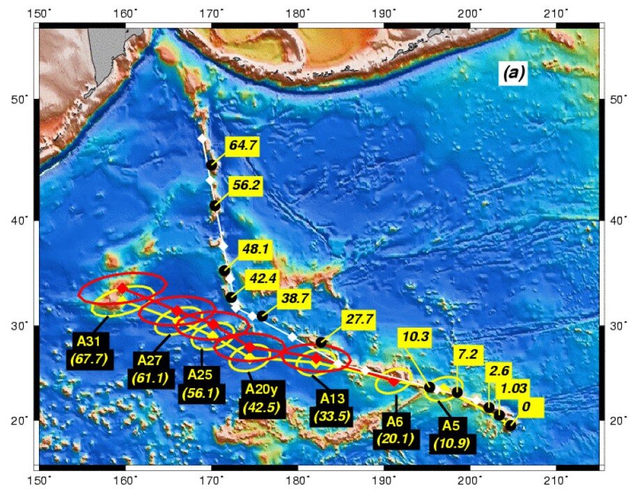
The map shows the actual position and age (yellow boxes) inferred from the seafloor magnetic anomalies of the Hawaiian islands and the Hawaiian-Emperor seamount chain. The diamond-shaped points and ages (black boxes) are the positions of the islands and seamounts that would be expected if the source of volcanism was a fixed plume and the present-day locations were determined purely by motion of the Pacific plate. The red and yellow diamonds reflect uncertainty about the motion of the Antarctica plate used to determine the fixed frame of reference for the plume.
Raymond, C.A., Stock, J.M. and Cande, S.C., 2000. Fast Paleogene motion of the Pacific hotspots from revised global plate circuit constraints. In: M.A. Richards, R.G. Gordon and R.D. van der Hilst (Editors), History and Dynamics of Plate Motions. AGU Geophysical Monograph Series. AGU Geophysical Monograph, pp. 359-375.

The map shows that the western Pacific is bordered by subduction zones, with the Aleutian trench to the north, west Pacific subduction zones off the coasts of Japan and China to the west, and between Java and Samoa to the south. This results in a radial-outward extensional force on the west Pacific lithosphere.

Global map of the tectonic stress field induced by horizontal tractions derived from the history of subduction. The arrows show the relative strengths of the extensional (outward-pointing arrows) and compressional stresses (inward-pointing arrows). Hawaii (red circle) is located at a point where the extensional forces are equal in all directions. In the podcast, Gillian Foulger suggests this may be causing lithospheric extension in Hawaii, which, according to the plate hypothesis, would cause volcanism from melting in the upper mantle.
Lithgow-Bertelloni & Guyunn (2004), Origin of the lithospheric stress field, J. Geophys. Res., 109, B01408, doi:10.1029/2003JB002467
Yellowstone

The location and time progression of volcanism in the eastern Snake River Plain. The prevailing view is that this traces the path of the North American Plate over a hotspot or mantle plume, now centered below Yellowstone National Park.
Courtesy of Kevin Case

Plate Hypothesis Explanation
According to the plate hypothesis, the time-progression of east-west extension of the volcanism in the eastern Snake River Plain is explained by the progression of lithospheric extension. While the plume hypothesis explains the trail of volcanism by the motion of the North American plate over a hot spot, Gillian Foulger points to the lack of evidence for a hot spot, and suggests an upper mantle origin of the volcanism following waves of lithospheric extension.
Christiansen, Foulger, & Evans (2002), Upper mantle origin of the Yellowstone hotspot, GSA Bulletin, 114, 1245
Further Reading
mantleplumes.org This website contains a rich discussion of whether or not mantle plumes exist and includes links to the relevant academic literature.