
Katie Stack on Mapping the Geology of Mars with the Perseverance Rover
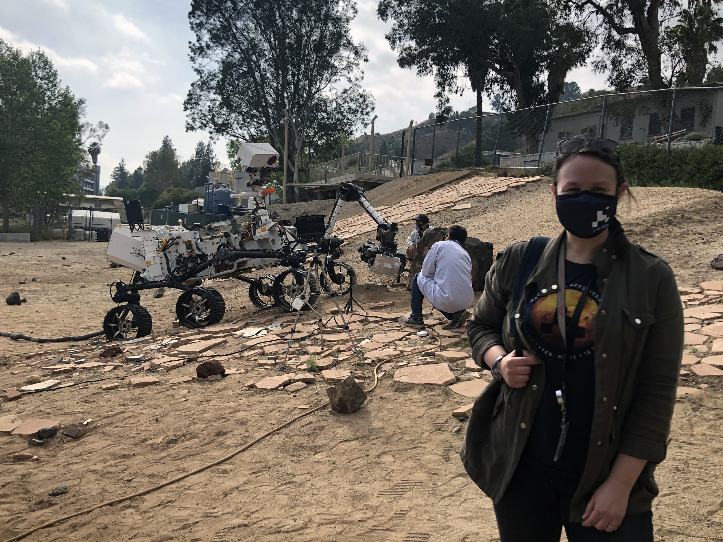
Katie Stack is Deputy Project Scientist for the Mars 2020 Rover Mission and an expert on the Martian sedimentary rock record. She leads a large team of scientists that will combine orbiter and rover image data to investigate processes that took place on the the ancient surface of Mars. Here she is testing a prototype in the “Mars Yard” at JPL in Pasadena, California.
Listen to the podcast here or wherever you listen to podcasts.
Scroll down for illustrations that support the podcast. And add your comments at the bottom of the page.
Note - playing the podcast is not supported on Internet Explorer; please use any other browser, or listen on Spotify, Apple Podcasts, etc.
Podcast Illustrations
The Perseverance Rover

In the podcast, Katie Stack discusses the imaging instruments on the mast (Mastcam-Z and SuperCAM) and the close-up camera on the arm (WATSON), as well as the subsurface radar (RIMFAX) and the UV (within SHERLOC) and X-ray (PIXL) spectrometers.
NASA/JPL

Perseverance and the helicopter (left) 13 feet from the rover captured by the wide-angle camera (WATSON) located at the end of the rover’s arm. The pale-colored rocks have yet to be identified.
NASA/JPL-Caltech/MSSS

Artist’s impression of Perseverance drilling to obtain a rock sample. Soil and rock samples collected by the rover will be retrieved and returned to Earth by a future mission.
NASA/JPL-Caltech
This video explains the various Supercam instruments aboard Perseverance and the measurements it can make.
Animation showing how the samples collected by Perseverance will be returned to Earth.
The Rover Landing Site

Simplified map of the regions in and around Jezero Crater prepared before landing. The green circle shows the rover’s landing ellipse. As part of Perseverance’s primary mission, samples will be collected from the crater floor, the delta, the marginal deposits, and the crater rim. Each of these areas may contain different kinds of evidence of the environment on Mars over 4 billion years ago. The region outside the crater, called Midway/Northeast Syrtis, might be explored after completion of the primary mission if the rover is still operational.
NASA/JPL-Caltech/USGS/University of Arizona

Perseverance landed within Jezero crater, just beyond the end of the fan-shaped river delta deposited by the ancient river bed that cuts through the crater rim on the left. The crater was once filled with a lake several hundred feet deep. The image is 31 miles across, and the crater in the middle of the delta deposit (red arrow) is about 0.6 miles across. The image was taken by the ESA Mars Express orbiter.
ESA/DLR/FU-Berlin/NASA/JPL-Caltech

The green dot shows where Perseverance landed in Jezero Crater on an image taken by NASA’s Mars Reconnaissance Orbiter.
NASA/JPL-Caltech/University of Arizona

A photogeological map showing bedrock and surficial units mapped by the Mars 2020 Science Team in and around the Perseverance landing site.
Rock Images from the Martian Surface

A rock carved by wind first noticed in the Mastercam-Z panoramic camera.
NASA/JPL-Caltech/MSSS/ASU

A rock named “Yeehgo” (a Navaho word for “diligent”) 11 feet away from the rover. As Katie Stack explains in the podcast, even with the state-of-the-art instruments aboard Perseverance, identifying rock types on Mars is difficult, and it is not yet known whether Yeehgo has a sedimentary or an igneous origin.
NASA/JPL-Caltech/LANL/CNES/CNRS/ASU/MSSS
The Road Ahead

This image shows two possible routes (blue and purple) from the landing site (white dot) to the fan-shaped delta deposits. The yellow line marks a possible subsequent traverse across the delta. The base image is from NASA’s Mars Reconnaissance Orbiter.
NASA/JPL-Caltech/University of Arizona