
Martin Gibling on Rivers in the Geological Record
Listen to the podcasts here or on your preferred podcast app.

Martin Gibling studies rivers and river sediments around the world. His research has focused on how rivers evolved between the Cambrian and the Devonian when land-based life began to flourish. He has also surveyed the record left by humankind’s effect on rivers from the earliest civilizations to the present day.
In the first of two Geology Bites episodes with Martin Gibling, he talks about fluvial deposits in the geological record and the impact of the break-up of Pangea on river systems. In the second episode, he talks specifically about the history of the rivers of Europe and the Americas, as well as the impact of recent ice ages. He ends by considering how humans have changed rivers and their deposits throughout human history.
Podcast Illustrations
Images are from Martin Gibling’s book River Planet (2021), Dunedin Academic Press

Geological timeline for the evolution of the Earth's rivers and other key events. Age dates from Ogg et al. (2016), A Concise Geologic Time Scale, Elsevier

Various structures within fluvial sediments can indicate flow direction. Left: cross-beds from the Triassic Hawkesbury Sandstone, Australia. Right: imbrication of boulders in the Cenozoic terrace deposits of the Yellow River, China.

The main types of river forms on modern river plains are the braided, meandering, and anastomosing rivers. A meandering river has a single sinuous channel. Braided rivers and anastomosing rivers both consist of multiple interweaving channels, but anastomosing rivers have semi-permanent channels separated by floodplain rather than channel bars. The front face of each illustration shows how deposits appear in a rock outcrop. As shown at bottom right, rivers running in valleys create structures that are tens of meters thick as compared to the 5-10-meter-thick features deposited by rivers in plains.

Zircon crystal from quartzite rock in the Jack Hills, Western Australia, shown in a colorized cathodoluminescence image. A date of 4.4 billion years based on U-Pb geochronology shows that the crystal is the oldest known piece of the Earth. The date confirms that a crust existed prior to 4.4 billion years ago, which supports evidence for a cool early Earth that was habitable by 4.3 billion years ago. John Valley talked about this in an earlier episode of Geology Bites.
Courtesy of John Valley

The Joggins Fossil Cliffs, Nova Scotia, Canada, are an example of river and shallow marine strata from the Carboniferous. They include fossil lycopsid trees that were entombed in their growing position when sand from shallow river channels swept through wetland forests.
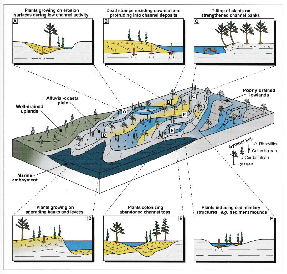
Relationships between plants and rivers observed in the Joggins Formation of Nova Scotia, Canada.
Ielpi et al. (2015), Journal of Sedimentary Research 85, 999
The Break-Up of Pangea and the Ancestral Rivers of Africa

The supercontinent Pangea, 200 million years ago, with dates of the breakup into separate continents.
Modified from Seton et al. (2012), Earth-Science Reviews 113, 212.

The longevity of modern rivers that still flow broadly in their ancestral courses.

The modern rivers of Africa. In the podcast, Martin Gibling explains the origin of the Niger’s unusual course (see below). He also suggests that as Pangea was breaking up, the Karoo (Jurassic) and Paraná (Cretaceous) mantle plumes caused southern Africa to dome upwards, with the effect that rivers such as the Zambezi, Limpopo, and Orange drained radially from the rising domes or were diverted around them.

Evolution of the River Niger. During the Cretaceous, the Benue followed a failed rift and was the predominant drainage until the Niger progressively captured its middle and upper reaches, forming a connected river perhaps as recently as 10,000 years ago.
Modified from Bonne, K.P.M. (2014), Geol. Soc., London, Special Publication 386, 327

Evolution of the River Nile. Through the Oligocene and Miocene, drainage flowed northwest and southwest from the rising rift flank of the Red Sea (top and middle), until the Nile settled into its northward course late in the Miocene (bottom).
Modified from Goudie, A.S. (2005), Geomorphology 67, 437
Australia

Modern rivers of Australia, showing the rivers flowing into Lake Eyre that are mentioned in the podcast, as well as the Channel Country, which includes Martin Gibling’s favorite river system.

Anastomosing channels of Cooper Creek cut into tough floodplain mud near Windorah in central Australia.
Courtesy of Google, CNES/Airbus Maxar Technologies
India and the Himalaya
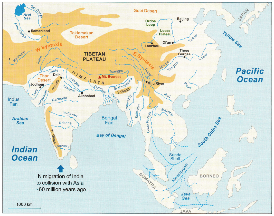
Rivers of modern Asia. Many of the depicted rivers are discussed in the podcast, as is the role of the Aravalli Range in northern India that diverted the Ganges away from the Indus, causing it to drain into the Bay of Bengal.

The maps show the evolution of Asian rivers resulting from the ongoing collision between India and Asia during the Cenozoic.

Inferred river histories, based on concepts developed on the Colorado Plateau by John Wesley Powell and colleagues in the late 1800s.

The Kali Gandaki Valley, more than 5 km deep, running south between the 8,000-m peaks of Annapurna and Dhaulagiri in Nepal. The river was antecedent to the most recent period of tectonic uplift, cutting down to keep pace with the rising mountains.

Former sandbed rivers (pale strata) and floodplain mudstones (red) of the Siwalik Group, laid down on Himalayan megafans and later thrust southward in the Siwalik Hills of India.
Europe
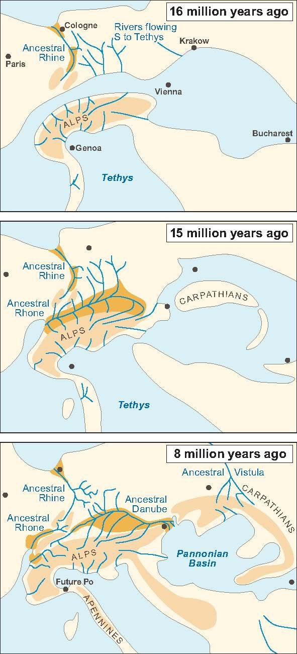
Evolution of rivers in the Alpine region, linked to the collision between Europe, Africa, and several small plates. As the mountain belts rose, rivers flowing south to Tethys were incorporated into the developing Danube, Rhine, and Rhone systems, and the Vistula flowed north from the rising Carpathians.
Modified from Kuhlemann, J. (2007), Global and Planetary Change 58, 224

Stages in the evolution of the Danube River. With a large load of Alpine sediment, the river delta advanced into a paleolake in the Pannonian Basin. After cutting gorges through the Iron Gates and elsewhere, the river connected to the Black Sea about four million years ago.
Modified from Olariu, C. et al. (2018), Terra Nova 30, 63

Stages in the evolution of the Rhine River. For much of its history, the river was made up of disconnected drainages. A connected Rhine from the Alps to the North Sea may be as little as three million years old.
Modified from Preusser, F. (2008), Netherlands Journal of Geosciences, 87, 7
South America

Stages in the evolution of the Amazon and other rivers in the northern part of South America. The 'Sanozama' river initially flowed west along the line of the modern Amazon, but drainage reversed to form the Amazon system as the Andes rose, generating a transcontinental river by nine million years ago. Carme Garzione discussed the history of elevation changes in the Andes in a previous episode of Geology Bites.
Modified from Figueiredo J. et al. (2009) Geology 37, 619

River Amazon at Santarém, Brazil, where the tidal range is about 20 cm. The photo is a low-season composite (probably taken in December), and islands and sediment bars will be underwater by about March. The Amazon controls the level of the tributary Tapajós River, which forms a natural reservoir for about 100 km upstream from the confluence. The Santarém region hosted many indigenous settlements, and dark anthropogenic soils generated by indigenous cultivation are common.
Context provided by Myrtle Shock. Maps data: Google, Maxar Technologies CNES/Airbus Landsat/Copernicus.
North America

Stages in the evolution of North American rivers. Northwestward Cretaceous drainage from the Appalachian Mountains was progressively replaced by eastward drainage from the rising Cordillera from the Paleocene onwards, with an increasing influx to the Gulf of Mexico.
Modified from Blum, M. and Pecha, M. (2014), Geology 42, 607

The Grand Canyon in Arizona, where the Colorado River has cut through flat-lying Mesozoic and Paleozoic strata. The Great Unconformity between Cambrian strata and underlying dark Precambrian metamorphic rocks is visible low in the canyon. Much of the canyon was cut within the past six million years. Becky Flowers discussed the Grand Canyon and the Great Unconformity in a Geology Bites episode about the thermal history of rocks.

Stages in the evolution of rivers draining into the Gulf of Mexico from the Paleocene onwards. Tectonic and volcanic activity in the Cordillera, rejuvenation of the Appalachians, and the southward advance of the Laurentide Ice Sheet caused individual rivers to vary in importance.
Modified from Galloway, W.E. et al. (2011), Geosphere 7, 938

Changes in drainage associated with the last Ice Age. The Yukon River initially flowed to the Pacific but later reversed its drainage to the Bering Strait. The Mackenzie River follows a meltwater valley along the mountain front to the Arctic Ocean, cutting through the former Bell River drainage, and may be as little as 12,000 years old.
Modified from Duk-Rodkin, A. et al. (2001), Quaternary International 82, 5

Dry Falls cut into basalts of the Channeled Scablands, Washington State. In the podcast, Martin Gibling talks about the catastrophic floods that are inferred to have shaped this landscape. This is discussed in more depth in the episode on megafloods with Vic Baker.

Part of the Channeled Scablands of Washington State, incised through a blanket of loess (wind-blown deposit) into bedrock of the Columbia Basalt Plateau.
Maps data: Google, Landsat/Copernicus

Channeled Scablands and glacial lakes bordering the Cordilleran Ice Sheet. The outburst floods were caused by collapse of an ice dam from a lobe of the Cordilleran Ice Sheet, which held back Glacial Lake Missoula.
Modified from Waitt, R.B. et al. (2019), Northwest Science 92, 318
Sea Level Rise After the Last Ice Age

Channel River, which united many of the rivers of Western Europe before its lower course was drowned by post-glacial sea-level rise, leaving its tributaries as disconnected modern rivers.
Modified from Gibbard, P.L. (2007), Nature 448, 259 and Bridgland, D.R. (2003), Proceedings of the Geologists’ Association 114, 23

Subsea topography of the English Channel, showing the former Channel River. The river formed largely by great floods after the Weald-Artois ridge was breached in the Dover Strait when the ridge was overspilled by a glacial lake in the southern North Sea.
After Gupta, S. et al. (2007), Nature 448, 342
Humans, Rivers, and the Geological Record

Timeline and stages for anthropogenic modification of river systems, based largely on information from the Near East, North Africa, Northwestern Indian Subcontinent, China, and parts of Europe. The timing and intensity of anthropogenic influence vary greatly regionally, with some stages bypassed completely.
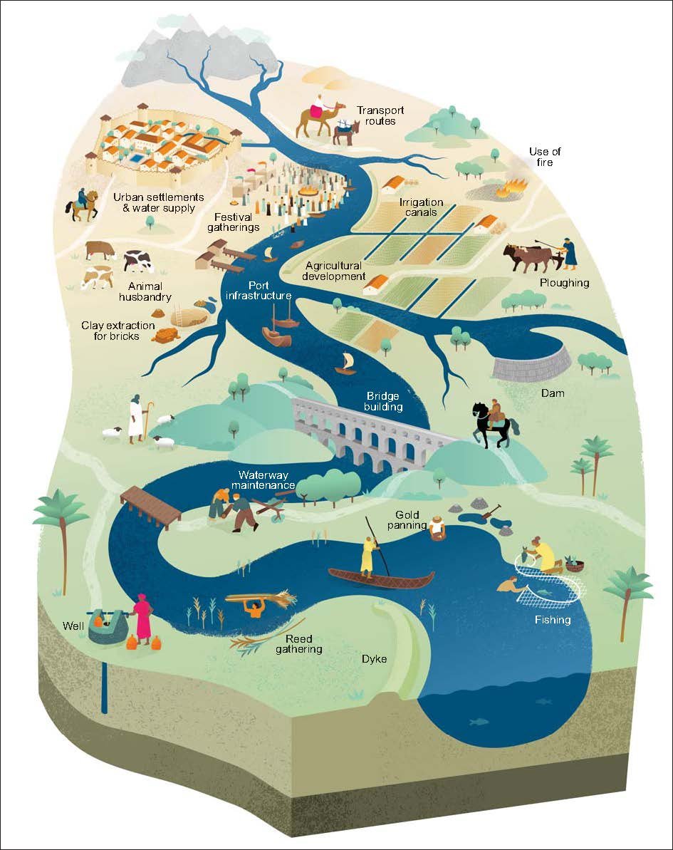
Schematic diagram showing the range of anthropogenic influences on river systems, especially from about 10,000 to 4,000 calendar years BP (Before Present).
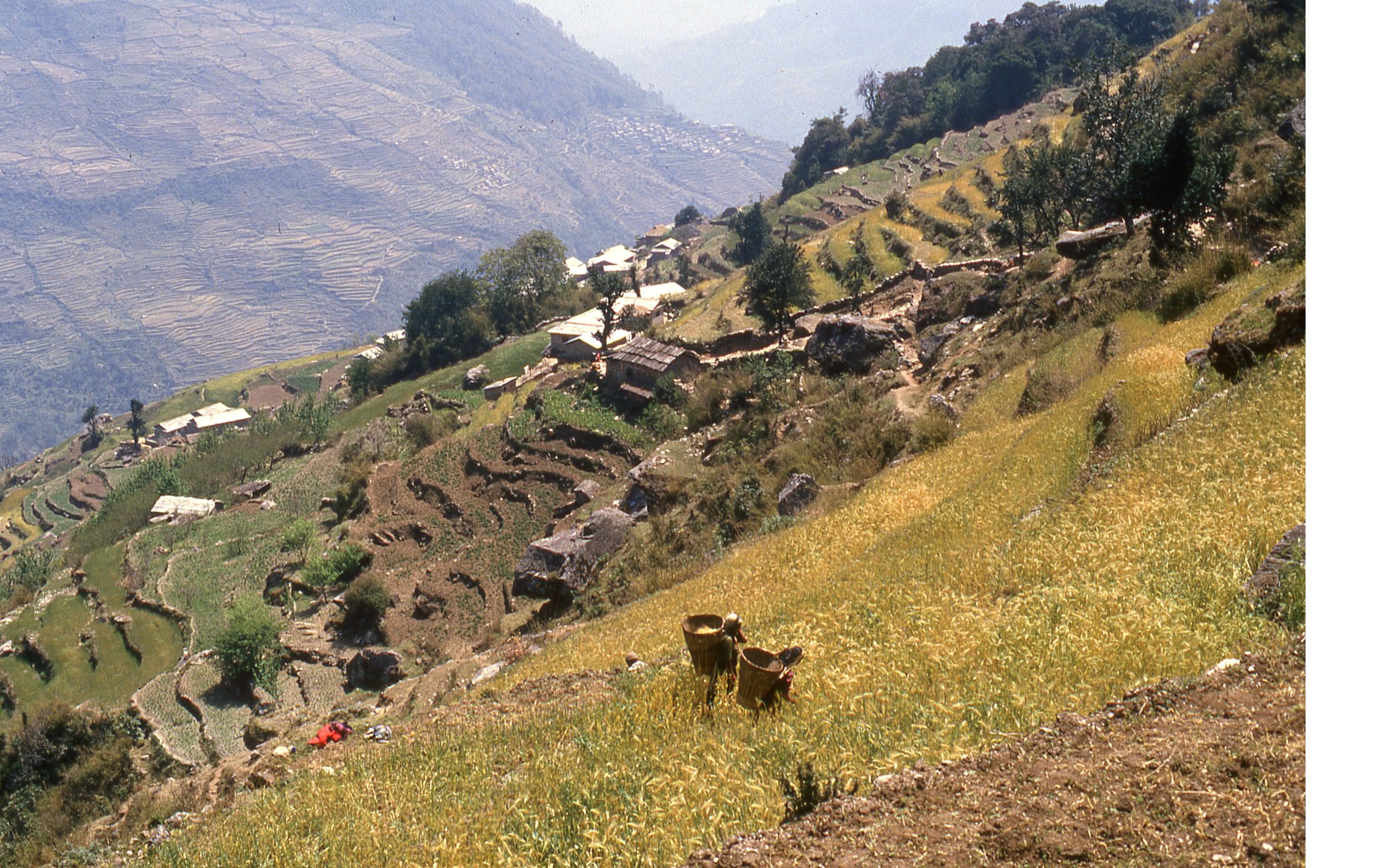
Terraces in the Himalayan Foothills, Nepal, with harvesting of barley. Terrace systems were generated in the Middle East at least 6,000 years ago.

Glen Canyon Dam on the Colorado River in Arizona, completed in 1963. The dam holds back Reservoir Powell, which stretches for 300 km through the canyon country.