
Mike Howe on the the UK National Geological Repository

Mike Howe is Head of the UK National Geological Repository. He explains what distinguishes the repository from a museum collection, and picks out some special examples from the collection, such as cores from the largest North Sea oil field, and the fossil that resolved a long-standing riddle as to the nature of the conodonts.
Listen to the podcast here or wherever you listen to podcasts.
Scroll down for illustrations that support the podcast. And add your comments at the bottom of the page.
Note - playing the podcast is not supported on Internet Explorer; please use any other browser, or listen on Spotify, Apple Podcasts, etc.
-
This transcript was generated automatically and lightly edited for readability.
Oliver Strimpel: This is Geology Bites with Oliver Strimpel. Many countries have national museums that house collections of rocks, minerals and fossils, but the UK has two major collections: the one at the Natural History Museum in London, and in addition, the National Geological Repository, located at Keyworth near Nottingham, which is part of the British Geological Survey and which actually has the larger of the two collections.
Mike Howe is head of the National Geological Repository. Under his leadership, the British Geological Survey has become a world leader in promoting access to the collection through digitization and web delivery. Perhaps most remarkably, 3D digital models have been made from 3D scans of over 2,000 of the type fossils in the repository. Mike Howe, welcome to Geology Bites.
Mike Howe: It's a pleasure to talk to you.
Oliver Strimpel: What distinguishes our national repository from a museum collection?
Mike Howe: Well, there tends to be only one national repository per country, and they often concentrate on borehole core and samples, particularly from mineral boreholes or hydrocarbon wells. They underpin the development of key mineral resources and can contribute significantly to the country's economy. Now, safely drilling a borehole is very expensive. It can be easily a million pounds plus onshore, and often 10 times that offshore. You can't just drill down 2,000 meters and take out a 2,000-meter-long stick of core and put it in boxes. You have to do it a few meters at a time, and it's the pulling everything out, retrieving the core and then putting it back that takes the time and costs the money. If you were to re-drill everything in our store, we estimate it would cost probably over 200 billion pounds. If you're an oil company considering drilling an exploration well, being able to study the cores and samples drilled by other companies nearby enables you to reduce the risk and increase the likelihood of success before actually investing in a particular project.
Oliver Strimpel: So can you give us an overview of what the repository contains?
Mike Howe: It is wide. We have over 600 kilometers of borehole core. So if you are drilling for oil, for example, as you drill down, sometimes you take solid sticks of core so that you can study the sedimentary rocks, or the rocks you encounter, in detail. And that's often the case if you're drilling a borehole to look for minerals or coal; you'll probably take solid rock out of that. And if you took all these sticks of core that we've got and put them end to end, it's over 600 kilometers. In addition to that, we've got another probably couple of million samples from boreholes, and then a million other rock and mineral specimens, three or four million fossil samples, and the whole total comes to something like 60 million specimens.
Oliver Strimpel: Of course, that's enormous. What is the national repository used for?
Mike Howe: Well, the collections are used partly for our reports, maps and publications. And more importantly, the samples are available for new projects, probably using different, new techniques: so-called repurposing. Studying one of our archive boreholes is often more productive than drilling a new borehole, because there's often already a lot of data available. And we actually encourage the subsampling of the cores and samples for further analysis, on the condition that the data and results are returned and added to the archive. The repository collections are also used for education and training, and each year, or each normal year, we accommodate a large number of commercial and academic visitors. And we even loan smaller specimens for specialist research and for exhibitions.
Oliver Strimpel: Could you pick out some particular items from the collection that you find especially interesting?
Mike Howe: Well, if we look at cores to start with, one of those I'd like to highlight is core from the Forties oil field. This is the largest oil field in the North Sea, discovered by BP in 1970, and oil started to flow in 1975, and it changed the economic fortunes of the UK. Now, the reservoir for this oil is roughly 60-million-year-old sandstone. It was formed from the rapid erosion of Scotland, due to the uplift related to the volcanism that was then going on along the Western Isles, on the west of Scotland. And because it was deposited rapidly, it's not that strongly cemented. But it represents really a resource that at the time, I think, accounted for something like a fifth of the petroleum needs in the UK. So it was a major player in the UK's economic fortunes during the 1970s and 1980s. And if you go onto our website, we have high-resolution photographs of all the core from hydrocarbon wells, and you can actually locate some of this poorly consolidated Forties sandstone.
If I think of another thing: when you drill a borehole or an oil well, it is very expensive, and there are other ways of working out what's beneath the ground. You can extrapolate from a surface map, or you can use geophysics. You can measure gravity, and that can give you an idea of the density of the rocks below you. You can check magnetics, and you can do seismic studies. Normally it works, but they will occasionally get it slightly wrong, and a good example of that is the Mochras borehole on the northwest coast of Wales. It's a very deep hole, 1,938 meters deep, and they expected from the geophysics that it would be in Lower Paleozoic rocks, that's rocks of 400, 500 million years, very similar to much of what you find in Wales. But what they actually found was Tertiary and Jurassic rocks, so that's rocks from sort of 50 to 200 million years, so much younger than they were expecting. And that's because of a major fault between the Mochras borehole and the rest of Wales.
Another good example is the Rookhope borehole in Weardale, northeast England. Now, there was a lot of discussion on the origin of the mineralization in the northern Pennines. In Cornwall, the mineralization is clearly related to the emplacement of the granite, and it was suggested that the same happened in the northern Pennines. And geophysics studies, in fact, picked up a lighter granite around 400 meters' depth below Weardale. And when it was drilled in the 1960s, they indeed found a granite at 390 meters down the borehole, but they also had a surprise. They were expecting that the granite had intruded the Carboniferous rocks at the base, where the mineralization is. But in actual fact, it turned out that the granite was at least 50 million years older, and there's an unconformity. In other words, you could see an erosion surface on the top of the granite, representing this break of some 50 million years between the exposure of the granite and then the deposition of the Carboniferous rocks. So in this case, it wasn't the direct emplacement of the granite that had produced the mineralization, although it is believed that the emplacement of the granite has affected groundwater circulation that actually promoted the mineralization.
Oliver Strimpel: Could you give us an example from the collection of fossils?
Mike Howe: Yes. I think one of my favorite projects has been working with the so-called Ediacaran, or Precambrian, fossils. We've got a really interesting example. We've actually got 120 square meters of silicone rubber molds and plaster casts of a bedding plane in the local Charnwood Forest Ediacaran rocks. This is a very famous area for Ediacaran fossils. Now, the story actually goes back to 1848. We have a letter from James Holley, a local naturalist, to Professor William MacGillivray of Aberdeen University, describing how, on a visit to a place called Green Quarry, he had discovered some fossils that included, as he described it, "seal-like impressions, like an ammonite." So they assumed that these were some sort of primitive fossils. It was visited by Survey officers in the 1850s, and they interpreted the rings as seaweed actually being sort of rotated by the tides and the swell of the sea.
But then in the 1870s, two Cambridge petrologists looked at them, and because they were virtually circular, they thought that they were relatively recent inorganic concretions. The logic was that if they were original fossils, when the rock was deformed into slate, they would have been deformed into ellipses. But the story continues in 1957, when a local schoolboy, along with a couple of his mates, went climbing in the quarry, and they found, as well as the discs, a frond. Now, it looked like a plant, though it's subsequently turned out not to be a plant, but they reported their findings, first through their schoolmaster, and it got to Trevor Ford, who was a lecturer at Leicester University. He visited and realized it was definitely a fossil, definitely in Precambrian rocks, and he published it in 1958. And on the basis of this definite discovery of Precambrian fossils, some Australian fossils that had been found a few years earlier, in a sequence of rocks from the Precambrian into the Cambrian, and therefore interpreted as very early Cambrian fossils, were now realized to be Precambrian too.
Oliver Strimpel: Presumably some examples of fossils in the collection have helped us nail down the dates of certain sedimentary strata?
Mike Howe: Yeah, a good example of that: we have very large collections of fossils called graptolites. Now, this is an extinct colonial organism, a planktonic organism, in the group of hemichordates. It's related to Rhabdopleura and Cephalodiscus, which are actually alive today. These are colonial animals that encrust pebbles on the seafloor off the south coast of England and the bottom of Norwegian fjords. But their relatives, the graptolites, were planktonic and very widespread. They also evolved quickly, which means that they are excellent for correlating rocks. And Charles Lapworth, who was a schoolmaster, demonstrated in the late 19th century that you could use them in the Southern Uplands of Scotland, which is a fossilized subduction zone, to actually tie the bits of rock in the area together and to put them into the correct sequence, because the rocks are strongly folded and faulted, and it is very difficult to make sense of what seems to be a large thickness of black shales. And Peach and Horne used this work and amassed large collections of graptolites when they were studying and mapping the Southern Uplands, to put structure and understanding into the whole area. But we still have these collections, and a modern interpretation of the graptolites means that we can actually increase the fineness of the correlation by a factor of 10 without actually going back out into the field, but purely using the collections that Peach and Horne had put together in the late 1890s, early 1900s.
Oliver Strimpel: Was that possible in part because the graptolites evolved rather rapidly? So you could quite easily distinguish different layers because of the morphological changes.
Mike Howe: It's exactly that. And graptolites are a really good example, because of the shell that's actually secreted by the graptolites, and it's a slightly strange way of doing it. It's not like a mollusk that has a mantle that just seems to secrete the shell around it in a fairly fixed pattern. In the graptolites, they actually have secretory organs that they can move around, so they actually add the shell like a series of bandages, almost. So they have quite a lot of capability of changing that rapidly in evolutionary terms. And of course, if you've got these rapidly evolving but widespread fossils, and if you find a particular species or subspecies in, let's say, Wales and Scotland, and probably Norway and Sweden, maybe Australia as well, then you know that those rocks were laid down at exactly the same time, give or take perhaps 100,000 years. And given that you're talking about 400 million years ago, that's a very precise date.
Oliver Strimpel: You have a collection of over 7,000 type fossils. What exactly is a type fossil, and what are some of your favorite examples?
Mike Howe: Every time somebody describes a new species of fossil, you have to select one example that represents that species, and you cite it in your descriptive paper, and that then becomes the reference sample for that species or subspecies. Take graptolites again: there have been cases where ideas or interpretations of species have been a little vague. So many graptolites were described initially from flat material, and then when they found material preserved in full three dimensions, certainly there was a little bit of confusion as to which 2D species were equivalent to which 3D. And if you've got a type specimen, then you've got some way of going back to try and work out exactly what a species concept is. And because, of course, the Survey collections go back a long way (in fact, they go back prior to 1835, because we have material that was in the collections of the Geological Society of London, and that goes back to 1807), because we've been around a long time, we have amassed a large collection of these reference, or type, fossils. And these are the ones that paleontologists visit on a regular basis, to compare with material that they've collected, to see whether or not their species are the same as the type.
An interesting story also: in the collection, we've discovered material that may have been around a little while, and its significance is only much later realized, and that's the story of conodonts. Now, conodonts look like teeth. They're microfossils made of calcium phosphate, first described in 1856, and they look like very, very small teeth. They're a millimeter or thereabouts in size. But initially, because they showed very little wear, there was doubt as to whether they were teeth or not. But they do occur in many shapes: there's cones, blades, some platforms. So presumably they do represent slightly different functions. Now, over time, they realized that there were certain commonly found associations, or assemblages. So you quite often find particular cones, blades and platforms together. And there were very rare examples, particularly in shale, of a whole assemblage of cones, blades, maybe platforms, preserved in life position, and they seemed to give you an idea of what the fossil might have looked like, or at least the orientation of the conodonts. But nobody had any evidence as to what the actual animal itself was. It presumably had no other hard parts than the conodonts, and had never been preserved.
But, and this is a good example of the value of historic collections, in February 1982, the paleontologist Euan Clarkson was visiting the Edinburgh collection, and Peter Brand, our curator at the time, commented to Euan, "Here's a strange creature. It's a fish of some kind." And when Euan examined it, he realized that around where the mouth would have been was a set of conodonts. He borrowed the specimen, took it to London, talked to another conodont expert, and a third expert happened to be in London for a meeting. He looked and agreed. They all agreed that this was indeed the conodont animal, and the discovery was announced in 1983. So it had been sitting in the BGS collections for a good number of years before its full significance was realized.
Oliver Strimpel: You've been a world leader in making your collection accessible to the public. Tell us how you did that.
Mike Howe: We started in the early 2000s with online databases of specimens, first with rocks and minerals, and then fossils, and then boreholes. And then by 2012, we started adding high-resolution images to some of these. So the first ones were high-resolution photographs of all our United Kingdom continental shelf (that's hydrocarbon) core. And we followed on with high-resolution images of thin sections of our rock collection. And so we have photographed all the slides we have of our reference collection of rocks, and they're all online for anybody to use and study. And it's not just a few. We actually have 160,000 of these online. Go pretty much anywhere that you can look in Britain, and you'll find that we've got a thin section with photographs online.
Oliver Strimpel: What about access to the fossil collection?
Mike Howe: Again, there's an online database, and we've also laser-scanned 2,000 of the best fossils to produce 3D digital models. And that's what we call the GB3D Type Fossils online database, and they're all there for anybody to use, purely free for academic and personal use.
Oliver Strimpel: That's a fantastic resource. We'll put a link to GB3D on the podcast web page at geologybites.com. You also created something called the GeoIndex. What's that?
Mike Howe: Oh, the GeoIndex. It's a GIS system, or geographical information system. It's basically a map of Britain with a couple of hundred datasets that you can select and turn off and on. You can look at a map and you can pull up, for example, the geology at a variety of scales. 50k, for example, is the standard one that normally gives you the most usable detail. You can pull that up, and then you can click fossils, or rock and mineral samples. And if you select the rock collection, you'll see little triangles wherever we have a rock in the collection, and if those are black triangles, it means that we've actually got a photograph of a thin section. So as I say, in total there's about 200 different datasets, ranging from borehole locations; there's geophysics, including gravity and magnetics; there's areas of outstanding natural beauty, mineral planning areas. There's a whole slew of different datasets. The main GeoIndex we have is the onshore one, but we have another very important one for offshore as well.
Oliver Strimpel: Yeah, it really does have an extraordinary number of layers that one can choose to display. I came across one of building stones.
Mike Howe: Building stones is excellent: a selection of just under 5,000 building stones, all photographed at fairly high resolution, that you can use again for any sort of academic or personal projects.
Oliver Strimpel: And we'll also put a link to that on the podcast web page. Mike Howe, thank you very much.
Mike Howe: Many thanks. I've really enjoyed talking to you.
Oliver Strimpel: For more about Geology Bites, as well as pictures and diagrams that illustrate this podcast, you can go to geologybites.com.
Podcast Illustrations
All images courtesy of BGS UKRI

The National Geological Repository houses its 16 million specimens in its Keyworth, Nottinghamshire facility.

The portion of the Rookhope borehole from a depth of 1,460 feet that revealed the granite with the unexpected erosive surface (unconformity).

Complex veining of sphalerite (zinc sulfide) and fluorite in a Carboniferous limestone from a depth of 690 feet in the Rookhope borehole.

Ammonite fossil.
Dactylioceras anguiforme
From the Jurassic of Barrington, Somerset.

Graptolite fossil. Graptolites are a marine, free-floating colonial animal. Their morphology evolved rapidly during the Paleozoic, which makes them very useful for correlating and dating rocks, especially during the Ordovician and Silurian periods.
Diplograptus (Orthograptus) rugosus apiculatus Elles & Wood
From the Ordovician of Laggan Gill, Scotland

The Ring Pit Quarry with slates showing concentric rings. The photograph was taken in 1894, but it was not until 1958 that the rings were conclusively identified as a newly-discovered frond-shaped Ediacaran fossil species.

One of the large “ring” fossils from the Ring Pit quarry. It is now recognized to be the holdfast structure of a rangeomorph informally termed “the dumbell.”
Wilby, P.R, John N. Carney, J.N., and Howe, M.P.A., Geology (2011) 39 (7): 655–658.

Screenshot of a search result for a trilobite using the National Repository’s GB3D fossil database. The database includes three-dimensional scans and high-resolution photographs of 2,000 type fossils.
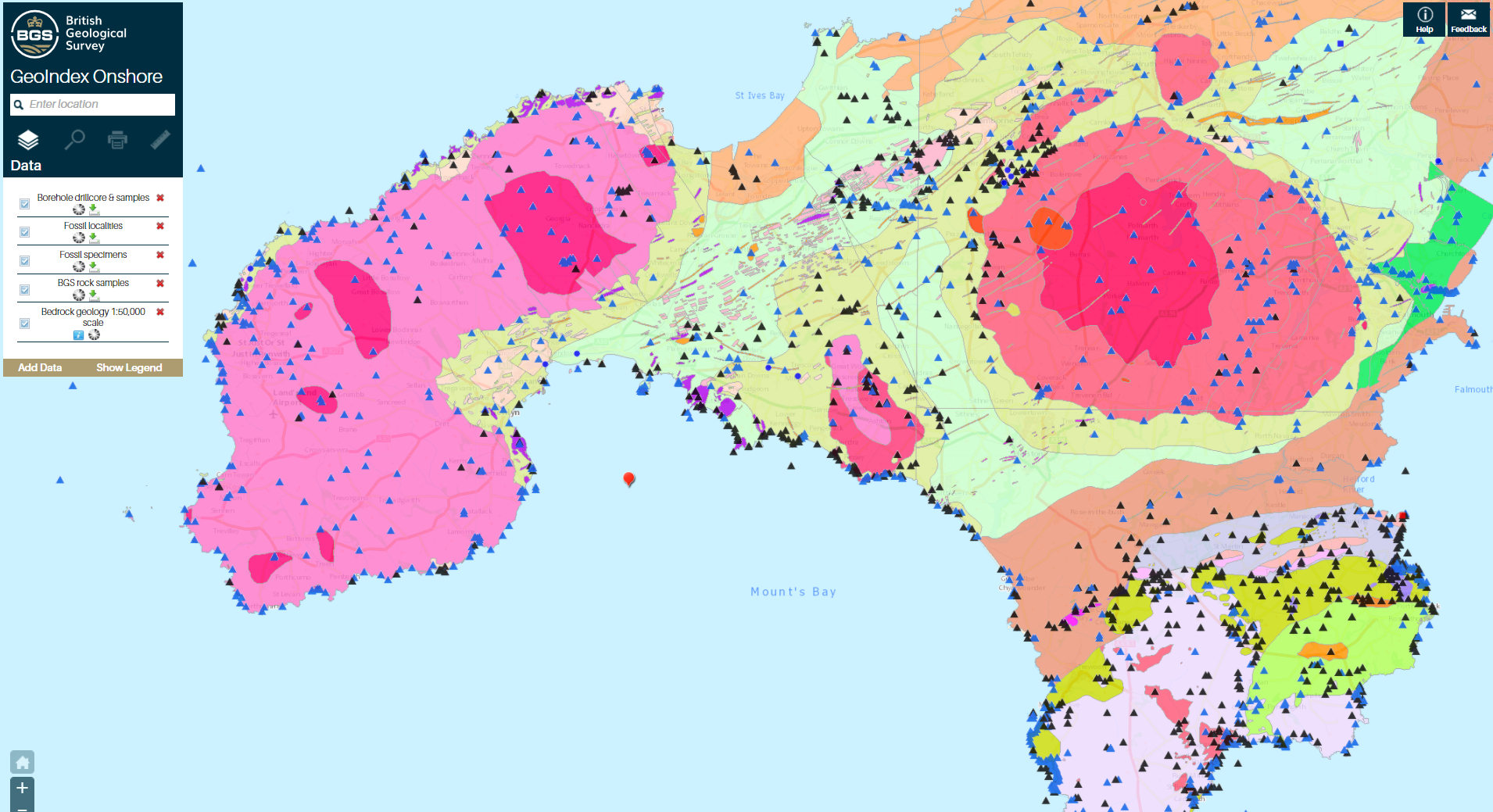
Screenshot from GeoIndex, a geographical information system enabling the public to choose from over 200 layers of data. Examples of the data layers include bedrock geology, boreholes, hazards, geochemistry, contaminants, geophysics, minerals, and environmental designations.