
Mike Searle on Why Mountains Exist

Mike Searle in Annapurna Sanctuary, Nepal
Mike Searle is Professor of Earth Sciences at Oxford University. He studies how mountain belts evolve, focusing especially on the chains of mountains that stretch from the Himalaya to the Alps. As a classical field geologist and intrepid rock-climber, he has explored, mapped, and geologically interpreted much of the Himalaya, the Karakoram, the Tibetan Plateau, and Southeast Asia. He has also investigated the Oman mountains in Arabia and their metamorphic rocks and ocean crust (ophiolite).
Listen to the podcast here, or wherever you get your podcasts.
Scroll down for illustrations that support the podcast. Comment on this episode at the bottom of the page.
Note - playing the podcast is not supported on Internet Explorer; please use any other browser, or listen on Spotify, Apple Podcasts, etc.
-
This transcript was generated automatically and lightly edited for readability.
Oliver Strimpel: This is Geology Bites with Oliver Strimpel. Much of the Earth's land surface is flat. There are huge steppes in Eurasia, tundra in the Arctic, grasslands and farmland in North America. We can easily imagine a simple flat planet with nothing but plains, but in fact, dramatic mountain ranges rise up on every continent. The distinguished geologist Mike Searle has been studying mountain ranges for 40 years. Mike Searle, welcome to Geology Bites.
Mountain ranges such as the Himalaya, the Andes or the Rockies are some of the most prominent features on the surface of our planet. Anyone trying to understand how the Earth has evolved over geological time has to explain how we get these huge topographic landmarks. So I'm going to jump right in and ask you: how do mountains form?
Mike Searle: Well, most mountain ranges are formed along plate boundaries. Everyone's heard of plate tectonics. This is the theory that divides the Earth's crust up into seven or eight fairly large plates, and the plates move around, driven by convection in the mantle. Those convection currents come up and generate new crust along mid-ocean ridges, and they consume ocean crust as the crust plunges down subduction zones.
Oliver Strimpel: When we see convection, say, in the atmosphere, when air rises and makes clouds, it tends to be a fairly chaotic affair. So I suppose the convection in the Earth's mantle that drives these tectonic plates is also aperiodic, albeit at much larger scales. This means that the plates must all be moving in different directions, with plates moving away from each other along some of their margins, such as at the mid-ocean ridges you mentioned, but also bumping into each other on the other side.
Mike Searle: Well, that's the interesting part, where mountains get made. The Alpine-Himalayan chain runs pretty much all around the world, and it's a result of the collision of a series of southern continents that were all part of the great supercontinent called Gondwana, colliding with the northern continents, which are part of Asia. That collision between the two continental plates varies along strike, but there are very similar processes happening at the same time all the way, for example, from the Alps to the Himalayas, and even down towards Indonesia.
Oliver Strimpel: Well, it makes sense intuitively that mountains should form where plates are colliding with each other, but that is a truly gigantic scale you're talking about, from the Himalaya to the Alps. There must be a lot of diversity in what's happened along this collision belt, though, because the Himalaya is quite different from the Alps.
Mike Searle: Yes, that's true. The Alps and the Himalayas were both formed by continental collision, but they are very different indeed. As you say, the Himalaya is probably one of the simplest of the collision belts that we see, which is why it's such a beautiful place for a geologist to work. Along the Himalaya, we have a mountain chain about two and a half thousand kilometers long and probably 100 to 200 kilometers wide, and the processes of collision are very, very similar all the way along that mountain chain, from Pakistan to India, to Nepal, to southern Tibet. Using the geology, the stratigraphy and geochronology, which is how you date rocks, using fossils or radioactive minerals like zircon, we can determine the processes that formed that major collision belt. So, for example, in the Himalaya we know that the Indian plate and the Asian plate collided about 50 million years ago, roughly at equatorial latitudes, since when India has plowed on northwards, indenting into Asia as it goes and creating the Himalaya in the last 50 million years.
Oliver Strimpel: OK, let's talk, then, about what's gone on, and is still going on, during this drawn-out, 50-million-year collision. And I want to throw in an amazing fact, namely that we find fossils of marine creatures right at the very top of Everest. So how did rocks from the bottom of an ocean manage to find their way to the summit of the highest mountain in the world?
Mike Searle: That's absolutely correct. The summit rocks of Mount Everest, the highest rocks on the planet, 8,850 meters above sea level, are actually marine limestones. They were formed during the Ordovician, about 450 million years ago, and they still contain relict fossils. They have little tiny crinoid ossicles, ossicles of the stems of crinoids, which are sea fans or sea lilies that are still in the oceans today, and they are perfectly preserved in these limestones taken from the summit of Mount Everest.
So how did sedimentary rocks formed at sea level end up at nearly nine kilometers above sea level? That is because as India is colliding with Asia, the Indian plate is diving down beneath the Asian plate, and as it dives down, it is stacking units up. So all the sedimentary rocks that form the northern boundary of India are folded and thrust, and that folding and thrusting shortens the rocks. And as India dives down, it is continually jacking up the crust of Tibet as it goes. It's a bit like putting a jack underneath a car to fix a puncture: as the jack is continually wound up, the car goes up and up and up.
Oliver Strimpel: So was that devastating earthquake in Nepal in 2015 part of that jacking-up process, and were the mountains suddenly a bit higher after that earthquake?
Mike Searle: Yes, exactly. The Gorkha earthquake of 2015 was just one of a whole series of hundreds and thousands of earthquakes that have similarly affected the Himalaya through time, and that's how you build up mountain ranges like the Himalaya. Each one of those earthquakes results in the rocks moving, up to 10 meters in some cases, in some of the largest earthquakes. The Gorkha earthquake in Nepal was on a thrust fault, so it records shortening on the basal thrust as India dives down beneath the Himalaya. The rocks beneath Kathmandu shortened by up to a meter and a half instantly, and the mountains immediately to the north of the Kathmandu Valley rose by just over one meter in a few seconds. It may seem ironic, but the GPS stations we have scattered around Nepal showed that the highest peaks around Mount Everest actually sank a little bit. In fact, they sank because the whole of Nepal was tilted down to the north and up to the south. So the most devastating parts of that earthquake were along the northern side of the Kathmandu Valley, for example, where the rocks were raised by over a meter and horizontally shortened.
Oliver Strimpel: OK, I can see how a plate can jack up another plate when it's squeezed underneath it, but that still doesn't really explain how we get these spectacular peaks and valleys, as opposed to, say, a flat plateau.
Mike Searle: Well, it does make a flat plateau, in Tibet, to the north of the Himalaya. Tibet is by far the largest area of high elevation and thick crust anywhere on the planet. The average elevation of the Tibetan Plateau is 5 kilometers above sea level, and the crust is double the thickness of anywhere else around it, in India or on the continent; it's up to 70 or 80 kilometers today. The Himalaya is the collisional mountain range that borders the southern edge of this plateau. And the only reason we know what the structure of the crust is like underneath Tibet is from geophysics; you can't see it in Tibet. In the Himalaya you can see it. You can walk up any of the valleys, which drain north-south, and the most incredible thing about the Himalaya, which the early geologists discovered a hundred years ago, was that the further north you trekked along those valleys towards Tibet, the deeper the rocks exposed. So you have deeper, higher-pressure, higher-temperature rocks on top of shallower sedimentary rocks, and that is pretty unusual.
Normally on the planet, the deeper you go, you increase pressure and you increase temperature. So you would convert a sedimentary rock like a limestone or a shale to a metamorphic rock like a marble or a pelite. A pelite is just a metamorphosed shale, and it has distinctive metamorphic minerals from which we can derive an idea of the depth of burial of those rocks. As you walk northwards across the Himalaya, you're going progressively deeper as you go north, and this is what we call inverted metamorphism. So the whole of the southern slopes of the Himalaya, all the way along the mountain range, are actually upside down.
Oliver Strimpel: I don't want to keep harping on this question, but it's still not clear to me just how any of these geological processes actually make the mountains into the shapes that we see.
Mike Searle: Well, that is largely to do with the geomorphology. What we see today along the Himalaya is the result of dominantly glacial erosion. Mountains above 5 kilometers high are going to be glaciated. So when you trek up to Everest, for example, the Western Cwm, which is the classic climbing route up from the Nepal side of Everest, is a classic U-shaped valley. And those glaciers, the Khumbu Glacier, have eroded maybe three or four kilometers deep into the crust of Everest. So what we're seeing today on the surface, all those beautiful geomorphological mountains, are actually the result of dominantly glacial erosion, but also fluvial erosion. Further to the south, the rivers cut V-shaped valleys, and as you go further north towards the highest peaks, those V-shaped valleys become glacial U-shaped valleys, with the classic geomorphology of glacial erosion. Really, the glacial erosion affects only the upper few kilometers of the crust, and that's what makes the mountains that we see today.
Oliver Strimpel: OK, so we've talked about making mountain ranges like the Alps and Himalaya when two continental plates collide. What happens when we get an ocean plate colliding with a continental plate?
Mike Searle: Well, the classic example of that is the Andes in South America, which is a long linear mountain range, thousands of kilometers long, formed by a completely different process. It's the collision of two plates, but, as you say, the Pacific Ocean plate is subducting eastwards beneath the South American crust. As that plate subducts, it releases fluids, which melt the base of the crust to form very distinctive rocks that we call granite. Granite is a quartz- and feldspar-rich rock, which intrudes upwards, forming great granite batholiths. A batholith is simply a long, linear granitic structure, and it actually forms the substrate of some of the most explosive volcanoes on the planet, things like Mount Saint Helens, and the great eruptions that we see in South America and Central America. All the most siliceous volcanic rocks in the upper crust are part of the deeper granite batholiths. And the granite batholiths are exposed in some of the most classic climbing areas of the world: Yosemite Valley, for example, where the El Capitan granite is an example of one of these, or the Patagonian granite spires down in the southern parts of South America. In the upper crust above those granites are explosive volcanoes, which are made dominantly of rocks we call andesites, named after the Andes. They are much richer in silica than the rocks formed in the oceans, and hence they're much more explosive and much more dangerous.
Oliver Strimpel: So there's one more type of collision between two plates, and that's when no continental plate is involved and we have one oceanic plate colliding with another. If those also produce mountains, they certainly can't be built on top of a continent.
Mike Searle: Yes. No. Those are examples of island arcs, and island arcs are very important mountain ranges, because they actually form some of the highest topography that we see on the planet. The classic examples of island arcs are in the western Pacific, most notably the Mariana island arc, which stretches from south of Japan all the way down through the Philippines to Indonesia. And the trench where the Pacific Ocean is subducting to the west is actually the deepest part of the Earth today, 12 kilometers below sea level. Remember, Mount Everest is just under 9 kilometers above sea level, but the deepest parts of the oceans are even deeper. So you could actually say that the highest mountains on Earth are the volcanoes that make up parts of the Mariana island arc, if you go from the bottom of the trench to the top of the volcano. It's 12 kilometers. The rocks produced at island arcs are much more basaltic; they're sort of intermediate, compared with the explosive andesitic volcanoes we see in the Andes, for example. But there are other incredibly explosive volcanoes along island arcs, which we see in Kamchatka, Mount Fuji in Japan, Mount Pinatubo in the Philippines. All of these are examples of island arc mountain chains in all of the oceans.
Oliver Strimpel: OK, so you've told us about three very different kinds of mountain ranges that form near the edges of tectonic plates when they collide. So do we only see mountains on plate margins?
Mike Searle: Dominantly, yes. The longest mountain range is probably in the oceans, along the Mid-Atlantic Ridge, which runs all the way across the globe. Fortunately, in the north, the Mid-Atlantic Ridge is actually exposed on the island of Iceland, where we can see volcanoes forming along a rifting margin. Underneath the ocean, that is a very, very prominent mountain range that stretches right the way down the Atlantic, and the Atlantic is a growing ocean, so it's expanding with time. So mid-ocean ridges are important mountain ranges. They're not that high compared to the Andes, but they're very, very prominent. If you drained all the water out of the Atlantic Ocean, there would be an enormous range of mountains stretching across the entire globe, and they're all made of basalt. So they're much, much simpler than anything on the continents.
Oliver Strimpel: I'm wondering whether these kinds of mountains, perhaps with the exception of Iceland, happen only under the ocean.
Mike Searle: No, they also occur under the continents, and the classic example of this is the East African Rift, where the very old continent of Africa is splitting apart all the way down its eastern margin. In the far north of the East African Rift, in Ethiopia, is a place where you can see the ocean propagating from the Red Sea down into the continent. The Afar Triangle region, the Danakil Depression in Ethiopia, is an absolutely incredible place. It's below sea level, it's highly volcanic, and you can see faults and basaltic eruptions forming new ocean crust. That ocean crust in the north, in the Red Sea, has been there for about 10 million years, and as it propagates down into the African continent, it is forming the Great Rift Valley, where the two sides of Africa are being pulled apart, dominantly by mantle convection in the deep crust and the mantle below southern Africa. And the rifts are typified by huge volcanoes like Mount Kilimanjaro.
These are, again, very distinct volcanic rocks. They are not the same as the rocks we see along the mid-ocean ridges, and they're certainly not the same as the rocks we see in the Andes or in island arcs. They are much more alkali-rich basalts, because they are richer in elements like sodium and potassium. The whole of the African plate is actually rifting apart east-west, and the island of Madagascar is an older part of Africa that rifted off 20 or 30 million years ago, and there's now oceanic crust in between the two. Predicting ahead, maybe in 20 or 30 million years' time, the Red Sea will be expanding, pushing Arabia and Africa apart, and the African continent will be split into East Africa and western and central Africa.
Oliver Strimpel: So we've seen that mountain ranges form not only at existing plate boundaries, where a collision is going on, but also within a plate, where the plate is splitting apart and new plate boundaries are forming. Do these multiple types of mountain building on the edges of plates account for all of the mountains on the planet?
Mike Searle: Not all of them. There are other distinct mountains in the middle of the oceans. Islands like Hawaii or the Galapagos Islands are very unusual, because they are huge volcanic edifices sitting on top of what we call hotspots. These are anomalous thermal hotspots that go deep into the mantle, and they've been generating basaltic magma for a long, long time. Hawaii is the classic example of a hotspot island, and we can see, if we look at a map of the Pacific, that there is a train of islands going off to the northwest, eventually all the way across the Pacific to the Kamchatka trench. This is the Hawaiian-Emperor seamount chain, and those islands get progressively older as you go northwestwards away from the Big Island of Hawaii, which is the site of the presently active hotspot.
Oliver Strimpel: You've talked about several different kinds of mountain ranges that we can't really see because they're largely submerged: the island arcs, the mid-ocean ridges and the hotspot chains. If we emptied out the oceans, would they look different from each other?
Mike Searle: They would. If you drained the oceans, you would be surprised, because you would end up looking at thousands and thousands of isolated volcanic seamounts. The Pacific has literally thousands of these islands, and 90% of them are below sea level; we don't see them. The big ones that we do see, like Hawaii and Galapagos, are major hotspots that have been around for 40, 50, 60 million years or more. There are other ones in the Indian Ocean. For example, the island of Réunion is a very interesting volcano, because it is another one of these Hawaiian-type alkali basalt ocean islands, a fixed hotspot. And there is a chain of islands going to the north of Réunion, along the Chagos-Maldives-Laccadive chain, and it eventually ends up at the Deccan basalts in western India.
Oliver Strimpel: Mount Everest is nearly nine kilometers high, and you've said that the Mariana Trench is nearly 12 kilometers deep. What determines this? What determines how high mountains can grow?
Mike Searle: Various things. Mostly the tectonics defines whether you have a steady eruption of lavas, like Hawaii, which has gradually built up over a long period of time, or whether you have sudden, huge eruptions, like some of the island arc volcanoes along the Mariana Trench. But in the case of Mount Everest, the reason the Himalaya is so high, and Everest in particular is the highest point on the planet, is a trade-off between the tectonics that creates mountains and uplifts them, and the erosional forces, weathering and chemical erosion, that break them down and force mountains to come back down to sea level. Erosion always wants to maintain the status quo. So the quicker the plates are moving, the higher the mountains of the Himalaya grow, and erosion cannot keep pace with tectonics along the Himalaya. As soon as the Indian plate starts to slow down, tectonics will give way to erosion, and erosion will eventually wipe out the Himalaya and bring it down to sea level.
This is what's happened in the past. A lot of the Precambrian mountain ranges we see, for example, in northern Canada were probably Himalayan-type mountain belts in their day, and then 500 or 600 million years ago, they were eroded back down towards sea level and planed off. To an extent, that's what you see today in the great northern prairie lands of America and in the tundras of Arctic Canada. Those were big mountain ranges 500 or 600 million years ago, and they've been flattened by erosion.
Oliver Strimpel: So does that mean that when we see flat plains on Earth, they've all been mountainous and then flattened by erosion? Or have some of them actually escaped mountain-building events for all of geological time?
Mike Searle: No, no. A lot of the great flat places of the Earth today have escaped mountain building; they never were mountains. If you look at the great plains of central Asia, for example, the old mountain ranges in Europe go up towards the north and along the Carpathians, that sort of area, and everything to the north of that has never really been in a mountain-building phase, ever. In other places, for example in North America, most of northern Canada was involved in big mountain-building processes right up until 500 or 600 million years ago. Before that, they were very active mountain ranges, some of them like what we see in the Himalaya today, but they've been eroded down and have been pretty close to sea level for the last four or five hundred million years. So no, not all the flatlands of the Earth have been through mountain-building processes.
Oliver Strimpel: As plates continue to drift around the surface of the Earth, and mountain building on their margins, and within them above hotspots, continues, is the Earth going to get more and more mountainous over time?
Mike Searle: Probably not. During Earth history, the Earth has gone through cycles of big mountain-building processes. The Alpine-Himalayan cycle that we see at the moment, over the last 50 or 60 million years, has created many of the mountain belts that we see stretching all the way from the Pyrenees and the Alps, down through Iran and Oman, across the Himalaya, down towards Indonesia. That's the very young, very active collisional process that's forming mountains. In the geological past, we've seen other very large mountain ranges across huge tracts of the Earth. There was one at the time of the Caledonian and Appalachian, which was back in the Ordovician, 450 million years ago. That was another huge collisional mountain range that stretched all along the eastern seaboard of North America, right the way from the Amazon across up to Scandinavia. There was another one across central Europe, the Hercynian, about 250 to 300 million years ago, that formed the mountain range that we see across most of central and northern Europe today. So these things do go in cycles. But the average over the huge amounts of geological time that we're looking at, 500 million years in the case of the Phanerozoic, four and a half billion years in terms of total Earth history, probably maintains a continuance.
Oliver Strimpel: Now, for my last question, I'm going to ask you to speculate. If we could be time travelers and we sped about 100 million years into the future, what would we see?
Mike Searle: Well, you're asking me to play God now. What we would see, in my purely speculative mode, is a very different planet from what we're looking at today. I would expect that the Pacific and Indian Oceans would be getting smaller and closing, as those subduction zones consume crust. I would expect the Atlantic Ocean to be expanding, so that could become the great Pacific of its time in a hundred million years' time. Everything depends on the mountain ranges. For example, the Himalaya formed because India has been pushed northwards by the oceanic spreading centers in the central and southern Indian Ocean. If that stops, then the Indian plate would no longer indent and collide with Asia, erosion would take over, and the Himalaya would be flattened down to sea level. God forbid. They're the most beautiful mountains on the planet, and we rely on the Indian plate continuing to actively collide with Asia to make the beautiful high mountains we see today.
Oliver Strimpel: Mike Searle, thank you very much.
Mike Searle: My pleasure.
Podcast Illustrations

Collision of two continents, which creates mountains such as those stretching from the Himalaya to the Alps.

The Himalaya taken from the Space Shuttle, annotated with the main faults along which the Indian plate slides under Tibet.
Courtesy of NASA and Mike Searle

Geological section of the subduction of the Indian plate below the Asian plate. The high Himalaya is shown as in green (GHS: Greater Himalaya Sequence).
Courtesy of Mike Searle

Subduction of an oceanic plate below a continental plate. This produces a chain of volcanoes above the subducted plate, such as the Andes, which are being formed by the subduction of the Nazca plate below the South American plate.

A mid-ocean ridge in which new ocean plate crust spreads out on either side of the ridge. An example is the Mid-Atlantic ridge, which is creating new ocean crust and widening the Atlantic.
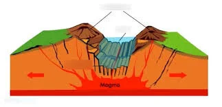
Rifting of a continental plate to create mountains on either side of the rift. The East African rift valley in Kenya is an example.

In the middle of a plate, volcanoes form over a “hot spot,” which is thought to be a hot plume of mantle that may extend to great depths, approaching the core-mantle boundary at 2900 km. Hot-spot volcanoes in the middle of a plate. The Hawaiian islands are above a hot spot in the Pacific ocean.

Colliding Continents
Mike Searle has a beautifully illustrated book about how mountains form when two continents collide. Along with the geology, it is packed with engaging accounts of a lifetime of exploration and adventure in places such as Nepal, Oman, and Myanmar.