
Neil Davies on the Greening of the Continents
Listen to the podcast here or wherever you listen to podcasts.
-
This transcript was generated automatically and lightly edited for readability.
Oliver Strimpel: This is Geology Bites with Oliver Strimpel. In several previous podcasts, we've talked about the emergence of complex life. For example, Susannah Porter told us about predatory eukaryotes that lived in the Neoproterozoic, about 750 million years ago, and Rachel Wood talked about fossils from the Ediacaran period, about 100 million years later, in the late Precambrian. All of these life forms, as well as those that appeared on the scene later during the Cambrian explosion, lived in water. It was not until about 460 million years ago, during the Ordovician, that life first emerged from water onto land. How did the early colonization of the land by life affect the landscape? And how do we study the sedimentary record to answer this question? Neil Davies studies the interconnections and feedback loops between life and sedimentation. His research aims to understand how such interactions manifest themselves in the rock record. He does this by combining analyses of sedimentary structures and textures, stratigraphy, and trace fossils. In 2018, he found a fossil of a giant millipede, fully two and a half meters long, by far the largest known arthropod in Earth history. We discuss this amazing find at the end of the podcast. Neil Davies is a lecturer in sedimentary geology at the University of Cambridge. Neil Davies, welcome to Geology Bites.
Neil Davies: Thanks for having me.
Oliver Strimpel: I said in my introduction that life did not emerge from water until about 460 million years ago, during the Ordovician. How do we know that?
Neil Davies: Well, what we know really comes from the fossil record, and the fossil record at this time is primarily one of spores and cryptospores. These microfossils occur quite widely as early plants came onto land. They disseminated their spores by air, and a lot of these ended up inside marine sediments. So given we've got quite a lot of marine sedimentary rock from the Ordovician, we can be pretty confident that the first land plants were taking hold in the Ordovician, around 460 million years ago.
Oliver Strimpel: What were those early land plants like? You mentioned spores, which at once makes me think of ferns, but what was it that first managed to colonize the land?
Neil Davies: Well, the first things to colonize the land were really small plants. They were the bryophytes, so things like mosses and liverworts: small, nonvascular plants, plants without roots, or certainly without very large roots, that were colonizing these coastal areas as the plants first made their foothold.
Oliver Strimpel: So when you say small, give me some idea of how big they are.
Neil Davies: Yeah, these are analogous to modern mosses and liverworts. They're a few centimeters high, mostly no more than one or two centimeters above the ground. So very small, very flimsy ones, with very weak attachment to the sedimentary substrate beneath them.
Oliver Strimpel: And did they immediately colonize all the continents?
Neil Davies: Well, they were pretty paleogeographically widespread when they first came on the scene. Most of the world's continents, certainly the coastal areas, were colonized by these earliest plants. But the evolution of land plants has a bit of a slow fuse, so pretty much nothing happens, or not much happens, for the first 40 million years or so of land plant evolution. It's after that point, when you get towards the Silurian and Devonian, that there's a sudden development of a whole host of different strategies that we'd recognize in modern plants, so larger, deeper rooting systems and so on, and increasing diversity of plant life. And that seems to have been focused in mid-latitude regions, mostly because at that time, paleogeographically, the equator, which we would normally associate with the highest biodiversity, is actually a string of small microcontinents, and it's the larger continents in the south that are enabling the diversification of plant life.
Oliver Strimpel: Okay, let's talk about the impact that this vegetation had on the land and the landscape, and what it is we see that reflects that.
Neil Davies: Well, the very first land plants, these mosses, these bryophytes: intuitively, they shouldn't have much of an effect, because they're small, flimsy organisms. And so if they're sitting around on the landscape and you've got wind and moving water, you'd expect that they're not going to put up much resistance to fluids on the land. But what they do do is increase chemical weathering quite dramatically. Each one of these individual plants, although it's got negligible rooting, acts as a kind of conduit between the atmosphere and the lithosphere. So you can imagine every single small plant as being almost like a tiny drinking straw, introducing water into the lithosphere, to the very surface of the lithosphere, for the first time, and promoting chemical weathering of labile minerals down to clay minerals. So that increases the amount of fine-grained sediment that we see. At the same time that this is happening, even though these are very, very small organisms, they still have some kind of effect on the surface roughness of the landscape. So the frictional contact between wind and water and sediment is roughened by the advent of these early land plants. So all in all, these things come together to suggest that early land plants should have some kind of effect, namely the production of a large amount of mud. And while it's hard to pinpoint that directly at an individual outcrop, when we look at the entire rock record, that's something that we do see evidence for. Prior to the Ordovician, there's pretty much no mud at all inside many alluvial deposits, deposits of sediment that were left behind on the land. And then, after the advent of vegetation, the amount of mud suddenly starts to skyrocket. And so by creating this mud, these early plants have the capacity to kind of vicariously affect landforms, because mud is a stabilizing agent. Mud is the cement to the bricks of sand in the sedimentary world. And so they start to stabilize floodplains; they start to stabilize riverbanks. So the advent of mud on the continents, which appears to be linked to the evolution of the earliest land plants, is a major shift in the way the surface of the Earth operates.
Oliver Strimpel: So how do we see the change in the landscape? Is the fact that there is more cohesion something we can actually see in the rock record, that shows us, for example, that mountains have a different shape, or that rivers have different shapes, as a result of this cohesive effect of the mud and the plants that grow in it?
Neil Davies: In the first instance, when we look at a pile of sedimentary rock and can understand that it was deposited, say, by a river, then we can look simply at the fraction of mudrock that makes it up. So if you look at a Cambrian succession of alluvial sediment, it's all sand or gravel. If you look at an Ordovician or Silurian one, then the amount of mudrock as a fraction increases. In terms of other changes to the landscape, as soon as you move into the Silurian and the evolution of tracheophytes, so plants with roots, then there's another element in the story of how plants can change landscapes, because rooting adds another element of stability, almost a deliberate element of stability, with plants colonizing areas that would normally potentially be eroded away. And so by stabilizing the landscape, you start to see certain features of river landscapes that are expressed in the rock record. For example, the curve of a meander bend is very frequently recorded as what we would call lateral accretion, which is a series of inclined strata, often alternating between sand and mud, and the abundance of lateral accretion sets really kicks off at the end of the Silurian. And that's when we start to see rooted vegetation starting to colonize the margins of rivers that have already been slightly stabilized with mud. And so together, these things act in concert to mean that we see a lot more evidence for meandering rivers after the evolution of land plants as well. Because prior to the evolution of land plants, many rivers would have adopted a braided morphology, a series of loosely shifting bars in the middle of a broad, wide, shallow channel, simply because the sediment that's coming into that river can't all be transported by the river during one discharge event, so it gets left behind in these temporary islands. Whereas once plants come on the scene and start to partition these river landscapes into discernible floodplains and channels, single-thread channels and curving meandering channels, then we start to see a lot more diversity in the architecture of the sedimentary rocks that record ancient river systems.
Oliver Strimpel: I wonder, is all mud biologically generated, or can you get mud from physical weathering?
Neil Davies: No, it's not, and you can get mud from chemical weathering in the absence of biology, in the absence of plants. But what's significant is this one-time evolution of a certain type of organism that we know directly affects the creation of mud. That happens in the Ordovician, and then it advances through the Silurian and Devonian. And so what we see instead, really, is a shift in the frequency distribution of mud. When we've looked at the volume of mud per river-deposited rock unit through time, what we see, for example, is that in the Precambrian and Cambrian, the amount of mud in those systems can be anywhere between nought and 20%, very rarely 20%; it's most often under 5%. But when we get to after the evolution of land plants, we see variance between nought percent and nearly 100%. So in other words, the potential to have extremely muddy systems appears. You could still have muddy systems in some instances prior to the evolution of land plants. Plants didn't invent mud, but what they certainly did was create a new pathway for its production and its retention on land.
Oliver Strimpel: Let's try and visualize these changes by summoning up a time machine that transports us back to the beginning of the Paleozoic, about 540 million years ago. What would our impressions be as we step out onto a lifeless Cambrian continent?
Neil Davies: Well, our best understanding of that should come from areas at the present day which we know have got a limited amount of vegetation. So a couple of good analogs that we could think of would be somewhere, for example, like the middle of the Sahara Desert, where you might have large sand dunes, in the absence of water. But where water is present, a good analogy comes from southern Iceland, around the sandur plains of southern Iceland. These are large braided river systems that extend out from the glaciers there, and there's a very limited amount of vegetation. And what it means is that whenever those rivers go into flood, for example during a period of glacial melt, they pump out so much sediment that even the coastline shifts back and forth. So it moves out and progrades with the addition of more sediment, and then it shifts back as the seawater and the coastal processes reclaim that sediment. And so that's quite a good analog, I think, for the pre-vegetation world. It's one in which landscapes aren't stable. If you don't have rock, if you just have bare sediment, that bare sediment is prone to move, because there's limited things keeping it in place: there's less mud, less cohesive sediment, and there's less biology keeping things in place. So every time the wind blows, the sediment moves; every time it rains, the rivers move. And they're also likely to be much more laterally mobile systems as well, because there's nothing keeping them in place. And so where a river is one year might not be the same place as it is the following year. So it's a very dynamic and unstable landscape, where sediment is simply being shed from bedrock.
Oliver Strimpel: If we got into a little helicopter and went from the equator to the poles, would we see much change in a Cambrian landscape?
Neil Davies: Probably not, because it seems that at the present day, many of the things that mediate the effect of climate on landscape are in the form of biology. The reason we see one type of landform in deserts is because you have particular vegetation there that's different from what we would see in the middle of a rainforest, or the tundra, or a temperate region. And so the absence of vegetation as a regulating mediator of climate might well mean that, actually, across the globe, what we see is pretty similar, and that's kind of borne out by what we see in the rock record. Wherever we look at Cambrian or Precambrian-age strata, from whatever paleogeographic location they were found in, we see very similar stratigraphic expressions, very similar sedimentary facies, mostly dominated by sand, representing these kind of large, unstable river systems.
Oliver Strimpel: Okay, let's zip forward in time to the Ordovician.
Neil Davies: So in the Ordovician, as I say, this is when the first plants are starting to get a foothold, and they're likely getting a foothold in the most marginal marine areas. They're certainly going to be preferentially colonizing relatively stable substrates, but where there is some kind of water availability. And so on the whole, the continents might not look too different, but their margins are going to look a lot more green, with these early mosses and bryophytes. One issue with really getting to grips with what the Ordovician continents would have looked like is that at the time, there's a multitude of smaller continents, and actually a lot less continental area than there is in subsequent or earlier periods. So we don't have such a direct constraint on what the facies of these Ordovician continents look like. However, just because there's less rock doesn't mean there's no rock, and there are plenty of places worldwide that again show a similar signature to what we see in older strata, perhaps with a little bit more mud. But generally, the Ordovician, with the earliest land plants in the first 40 million years of their slow-fuse evolutionary history, hasn't changed a great deal from earlier time periods.
Oliver Strimpel: Okay, so it seems like we need to move forward a little bit more in time, to the Silurian, which starts roughly about 440 million years ago. What would we see then?
Neil Davies: Yeah, and it's useful to bracket the Silurian and Devonian together, really, because that's the time of this major explosion in plant life. One of the most important things that happens towards the end of the Silurian and the start of the Devonian is that we begin to develop rooting strategies, and it's those rooting strategies that start to enable truly biogeomorphic landforms, so rivers that are directly controlled by the vegetation that surrounds them. So we see, for example, an abundance of small-scale and medium-scale meandering rivers at this time. We also see more evidence for long-lived floodplains, and, attendant with that, we also see the development of thicker soil profiles on those floodplains, because for the first time these floodplains are being taken away from the realm of potential reworking for tens of thousands of years, and there's a chance, in those areas where plants are going to grow, for more progressive chemical weathering in situ of the sediment that's around there. But that late Silurian phase going into the early Devonian is soon advanced even further by the evolution of lignophytes in the Devonian, so woody plants. And the evolution of woody plants, which eventually enables arborescent, tree-like vegetation to develop, really changes the system again, because not only are we adding an extra element of stability to landscapes, as trees tend to have deeper roots, but those trees are also acting to regulate climate in different climatic zones. They're also producing new sedimentary particles: parts of trees, wood and branches that fall from the trees. Those are sedimentary particles that interact with landscapes and landforms. So it's in the Devonian, coming into the Carboniferous, that we start to see the first logjam deposits. You've got to think that prior to the evolution of trees, there's not a huge amount of sedimentary material that could actually float; it's pretty much restricted to bits of ice. It's the evolution of these large amounts of woody debris that start flowing down these river systems that can clog them up and cause rivers to avulse. Just to explain, a river avulses when it rapidly abandons its channel and forms a new river channel. And so at this time, we start to see more evidence of fluvial planforms that are reliant on these processes. For example, anabranching rivers, which are these networks of multiple single-channel rivers, start to appear on the scene in the Devonian and Carboniferous, where we've got not only the capacity to clog rivers and cause them to avulse, but also the deeper rooting and drought tolerance of vegetation, which enables the build-up of levees. So when the river floods, it builds up sediment on the side. But in order for those levees to be stabilized, you need to have plants with deep enough roots to still get to the water table. So all in all, these things are showing this progressive evolution of river systems going forward.
Oliver Strimpel: So it sounds like, generally speaking, it would be a pretty familiar environment to us.
Neil Davies: Yeah, and certainly by the end of the Devonian, all the body plans, if you like, of modern vegetation are present, even though the plants themselves are actually different. So if we want to think about these things in terms of how they interact physically with their environment, all the shapes that we need and all the interactions with sediment are already in place by then. So it would be a very familiar environment, most likely by the end of the Devonian, but certainly by the start of the Carboniferous. The trees would be different, the plants would be different, but it's still a very recognizable environment in terms of the physical landscape. And we actually see some of that on a small scale too. So we see, for example, with some of these early trees, things like scour hollows in front of them, where water has moved around them. And if we find a standing fossil tree in the rock record, more than likely we're going to see evidence of how individual fluids have interacted with it on a kind of local scale. We see evidence of decaying vegetation, and sediment slumping into these decayed hollows. And so, ironically, at this time, as the trees get bigger, when the plants get bigger, it's more likely at an individual outcrop to start to pick out evidence for these really small-scale interactions. Whereas in the earlier record, in the Ordovician, we have to rely on that whole global picture to pick out the cumulative effect of all these apparently insignificant small plants acting in concert across the entire globe for the first time.
Oliver Strimpel: Hmm. You need the big structures to be able to trap the small structures in the sedimentary record.
Neil Davies: Yeah, that's right. The sedimentary record is pretty hierarchical, so small-scale features are components of large-scale features. A ripple is part of a river channel, is part of a whole catchment area, is part of a larger sedimentary basin. And so one of the aspects of the research that we've done really tries to frame our observations in the correct spatiotemporal scale. The smallest sedimentary features in the rock record tend to take seconds or less to form; a ripple can be generated almost instantaneously on geological timescales. Whereas a sedimentary basin might take many tens to hundreds of millions of years to form. And as we go from these smaller to larger features, and the timescales for their formation increase, it's very important that the observations you make are couched within the relevant spatiotemporal scale. So it's okay to go to a Carboniferous standing tree fossil and say, yep, on one particular day, there was water scouring around here, and that left a certain impression that's archived at the scale of an outcrop. But if we want to see a global picture, we need to take cumulative evidence from all the outcrops worldwide, and that often involves doing a kind of meta-analysis and deep-diving the literature to get all the information out from other successions.
Oliver Strimpel: Just coming back to the Devonian, and perhaps into the Carboniferous, then: because we now have substantial vegetation, I presume there are major latitudinal differences that we would see if we got back into the helicopter and traveled from low latitudes to high latitudes. We would see a big change, analogous to what we see today.
Neil Davies: Yeah, I mean, that should be right. Certainly by the time you get towards the middle Carboniferous, the most obvious remnant of that is the coal forests, so the large tropical rainforests and coal swamps that existed around the equatorial belt at the time. That equatorial belt pretty much extends across much of North America and into Europe. Towards the end of the Carboniferous, there's a big reorganization in the landscape and in terms of the flora, and that actually means that, partly due to the warming of Pangaea as a continent, many of those lycopsids that basically made up the rainforest tend to shift north and south, and there's actually a replacement in equatorial Euramerica by early conifers at that time.
Oliver Strimpel: Let me just interject to say that lycopsids are the oldest group of living vascular plants. They're represented today only as club mosses and quillworts, but their extinct members were the most important contributors to the Carboniferous coal beds.
Neil Davies: So yeah, we do see these things. We can pick the evidence of this out of the rock record. A very obvious way that you can check this out is that the age of coal deposits in central Pangaea, the supercontinent, is Carboniferous across Europe and North America, but if you go to northern and southern Pangaea, places like China, Russia and Australia, the age of the coal tends to be Permian, because the coal forests have shifted in their biogeography through time.
Oliver Strimpel: The other thing that I was thinking about, as you were talking about the increase in vegetation and its cohesive, retentive effect, is whether this would have an effect on the number and longevity of mountain ranges. If you don't have any vegetation, then presumably the weathering of orogenic belts that push land up to higher elevations, all that erosion, happens much, much quicker than it would if you've got the slopes forested and held together by vegetation. Is there any way we can document that?
Neil Davies: I suspect this is one for the modelers, because there are certainly things that we can play with as thought experiments to think about what would happen. For example, we know that in meandering rivers at the present day, the transfer of sediment from the source area to the marine realm is much slower than it is for braided river systems, and that's because of these kind of staging areas along the way, in the form of floodplains. So it's certainly possible that prior to the evolution of land plants, there was a quicker transfer of sediment from mountains through to the marine realm. But this is something that really requires some kind of modeling to be done to estimate it. Our problem is that in this instance, we don't have those ancient mountain ranges preserved; we just have their proxy record, in the form of the sedimentary record that's left behind. Whereas the factors regarding vegetation impact on sedimentary environments and landscapes, those are things we can actually directly go out and see. These are tangible records in the rock record, and you can go out and kind of touch these things in many instances.
Oliver Strimpel: When we talked earlier, you pointed out that much of the emphasis in sedimentary geology to date has been to capture the environment in which a fossil might have lived, but you're taking a fundamentally different approach, which you just touched on earlier, about spatial and temporal scales and how we should be interpreting the record of sedimentation.
Neil Davies: Yeah, I think it's very important that when we look at a pile of sediment, we don't just question what environment it might have been deposited in, but also how long it took for that to be deposited. The issue there is that if we start to read the geological record literally, as a kind of tape recorder moving at a constant rate, then we're going to set ourselves up for trouble, because things that appear to be rapid might actually have been happening very slowly, and things that appear to be accruing very slowly might actually be very rapid. So one aspect of the research we've been doing recently has been questioning, for example, why there are certain bedding planes in the sedimentary rock record that archive really, apparently, transient events: individual trains of ripples, or the delicate trackways of an arthropod crawling across there, or even individual rain showers, preserved by their raindrop impressions. The typical kind of explanation for some of these features has often gone to the idea that we have to find a special reason for these things to be preserved: these delicate things that we know about from our own lifetimes couldn't really be preserved unless we had some magic glue holding them together. And I think the answer is a lot more mundane than that. It really is that any individual bed, or small sedimentary phenomenon we see, is really part of a nested hierarchy that exists inside many different spatiotemporal scales. And so when we think about it like that, we can start to say, well, at the scale of an outcrop, we're looking at the very smallest scale. Our field of view has been discretized to the spatial minimum, and also, in many instances, to the temporal minimum. We can see the evidence for a rain shower inside there. So the question then is why did these get preserved? Why didn't the next band of sediment that came over the top erode those away? Well, that can be explained when we think about how these things fit into a wider area: not every pulse of sediment that's being deposited leads to erosion and then deposition at the same location. So the sediment that may have coated our raindrops might have had erosive power further away from our field of view, but when it came to rest in this particular small frame, it had not. And that's really just related to the fact that each individual band of sediment is being deposited by a fluid that's essentially dissipating energy. And we should expect that the rock record archives these mundane signatures, because it really is a very long-lived Earth, and these processes at the small scale are being archived on the small temporal scale of a few hours or minutes in many instances, because the same experiment has been repeated again and again. We should expect that these little slivers of time appear inside the rock record, and we don't need to seek special explanations for them.
Oliver Strimpel: So when you look at the record in that more scale-aware way, both temporal- and spatial-scale aware, are there new insights to be gained about the history of the Earth?
Neil Davies: Well, I think it just means that in every case study you approach, you are looking at things slightly differently. You're effectively recognizing that stratigraphic time isn't a vertical phenomenon, as it's often portrayed, but rather something that's smeared laterally across a basin. If you go to a basin at the present day, not everywhere is experiencing sedimentation at the same time. And so the trade-off between that nondeposition and these small patches of high-energy deposition means that in those patches where we are depositing sediment, we're actually recording a much smaller timescale than we would anticipate if we took the whole basin fill and just divided its volume by the time it took to accrue. So I think that's quite an important thing. It explains many issues, in terms of problems with correlation, for example, inside some strata, or it can explain apparently problematic fossil preservation. Going back to the Carboniferous trees, there have been papers that have suggested that the preservation of a standing tree fossil must require very rapid subsidence or very rapid tectonic movement, because how else would, say, a 1-meter-high tree trunk get preserved for the X thousands of years it would take to accrue sediment over the top of it? But in reality, of course, we know just from looking at the news that that's not the case. You see evidence of a big flood at the present day that can deposit two meters of sediment in no time. And so on geological timescales, we scale towards these events. It's really just an effort to try and explain the sedimentary rock record in the most mundane way possible, and strip it away from the sensationalist claims. Most of the rock record can be explained by the fact that the Earth has happily ticked over for the last four billion years, without everything having to be explained by a cataclysm.
Oliver Strimpel: I want to change track a bit here and say that I actually first heard about you about a year ago, when you and your students discovered a fossil that, at least from the extensive press coverage, sounded pretty sensational. Can you tell us about that?
Neil Davies: Yeah, this was this giant Arthropleura fossil that we discovered in Northumberland. It's Carboniferous in age. And what we have is part of the molt, the exoskeleton, of a giant millipede-like organism. Arthropleura has been known for a long time. There are small specimens of it and some moderately large partial specimens, but it's really been known most commonly by its trackway record. So if you go to many Carboniferous strata, certainly across equatorial Euramerica, you'll find these kind of staccato tramlines of footprints that are up to 50 centimeters apart, suggesting there were some very large arthropods walking around on land at the time. And while small pieces of cuticle of these things have been known, or fragments of legs, the record of complete or semi-complete Arthropleura is pretty limited. Actually, both of the really articulated specimens that were known came from Germany, both from the Carboniferous, and both of them only 30 centimeters wide. Our fossil, the actual remain itself, which is only two-thirds of the width of the body, is almost 40 centimeters. And so this animal was almost 60 centimeters wide. From looking at the width-to-length ratios of some of the small juvenile fossils that we do know about that are complete, we can then estimate that it was almost 2.7 meters in length as an original organism. The actual fossil that we collected is two sizable chunks of this animal, in two chunks of rock that each weigh about 50 kilos.
Oliver Strimpel: Wow. And how did you come across this? Were you looking for something in particular at the time?
Neil Davies: No, it was a chance discovery, with two former PhD students of mine. We decided in early 2018 that we were going to take a geological field trip that was essentially going to go around the entire geological history of England and Wales in the correct stratigraphic order. So we basically set off from Cambridge, started in the Precambrian of Leicester, went up to North Wales, then South Wales, across and up north, then back down to the south coast and around East Anglia. And it was on a little Carboniferous leg of this that we were just going to locations that we thought would be interesting to see. So we found ourselves at Howick Bay. We walked down to the cliff face there, looked at the Howick Fault, which is quite an impressive fault, looked through some of the structural features, and then looked at a little bit of the trace fossils in some of the lower Carboniferous there. And as we were heading back to the car (this was January, so it gets dark quite early and cold quite early), we just saw this big boulder that had fallen from the cliff, and looking inside it, we realized that there was this very large fossil. We weren't certain what it was to begin with. We moved to the idea that it might be this large Arthropleura, because we knew about these animals from reconstructions and museum dioramas. I wasn't aware at the time that these things were so rare, or certainly that such large fossils were so rare. But after consulting a few people who know more about these things, we confirmed that it was indeed Arthropleura. So we got the permissions, went up and collected it, and yeah, it's the largest arthropod ever discovered.
Oliver Strimpel: And by quite a bit. I mean, over two and a half meters long.
Neil Davies: Yeah. One of the things that has been suggested as the reason we saw these large arthropods was, for example, heightened atmospheric oxygen at the time. What's interesting about this one from Northumberland is that it actually dates from the Serpukhovian, so the late Early Carboniferous, and during that interval, oxygen levels aren't thought to have been much greater than they are at the present day. So that may not be the only reason that these things were able to get so big.
Oliver Strimpel: I guess I'm reminded of a comment you made earlier, that there really aren't that many exceptional things; most of the explanations are mundane. So do you actually view this giant arthropod as something mundane?
Neil Davies: It was something exciting, but it's mundane for the Carboniferous world. Maybe we don't need to find a special explanation for why these things got so big. Maybe that's very much a present-to-past perspective. Maybe they were just big. There are bigger animals at the present day; not arthropods as big, but elephants are bigger, horses are bigger. So there's not necessarily any need to explain these things as having some special reason. It's just that at the time, this is what the flora and fauna looked like. And I think this is why, again, outcrop-based, field-based sedimentary geology is good. It gives you these windows into these past worlds, and while they're not full of exceptional events, they're still pretty spectacular, and there's a lot to be found if people go out and look at these areas.
Oliver Strimpel: Neil Davies, thank you very much.
Neil Davies: Thank you.
Oliver Strimpel: For more about Geology Bites, as well as pictures and illustrations that support this podcast, you can go to geologybites.com.
Scroll down for illustrations that support the podcast.
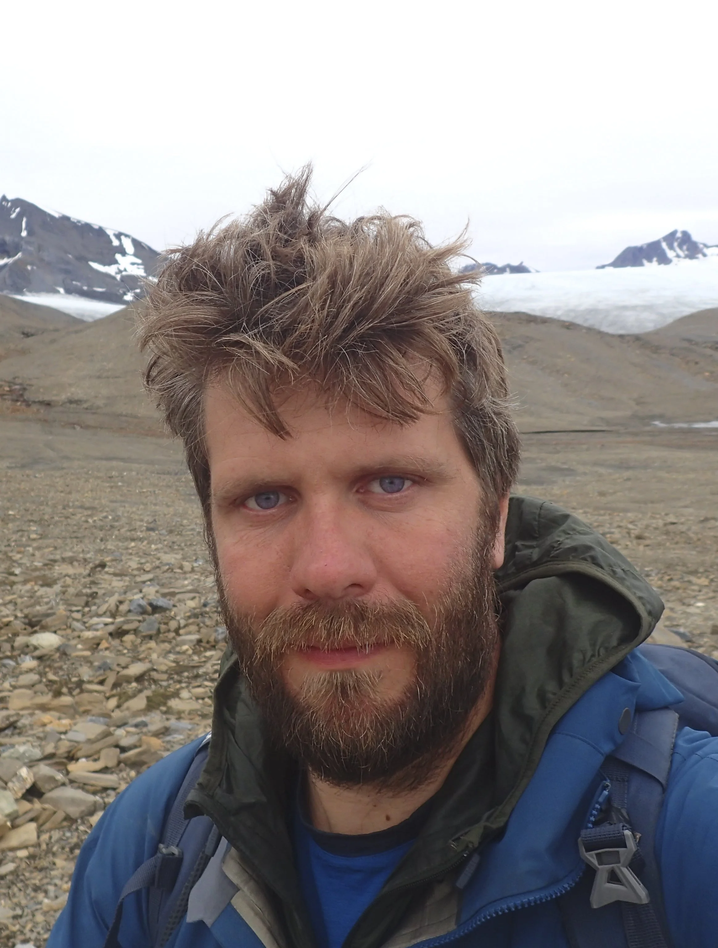
Neil Davies is a Lecturer in Sedimentary Geology at the University of Cambridge. He studies the interconnections and feedback loops between life and sedimentation. His research aims to understand how such interactions manifest themselves in the rock record. He does this by combining analyses of sedimentary structures and textures, stratigraphy, and trace fossils.
Podcast Illustrations
All images courtesy of Neil Davies unless otherwise indicated.

In the podcast, Neil Davies discusses the development of land-based plant life, starting on continental margins in the Ordovician, accelerating in the Silurian, and becoming widely established and diversified by the Devonian.
© International Commission on Stratigraphy, February 2022

Remains of early Devonian zosterophyll plants from the Andréebreen Formation of northern Svalbard, Norway. The zosterophylls are a group of extinct land plants that first appeared in the Silurian. They were among the first vascular plants in the fossil record, and had a world-wide distribution.

Reconstruction of an Upper Silurian zosterophyll.
Courtesy of Matteo De Stefano and Museo delle Scienze, Trento

Standing lycopsid trees in the late Carboniferous from the Sydney Mines Formation of Nova Scotia.


Diorama of a Carboniferous coal forest. The large trees with a grid-like pattern on their trunks are lycopsids.
Courtesy of the American Museum of Natural History
What is Exceptional and What is the Norm in the Sedimentary Record?
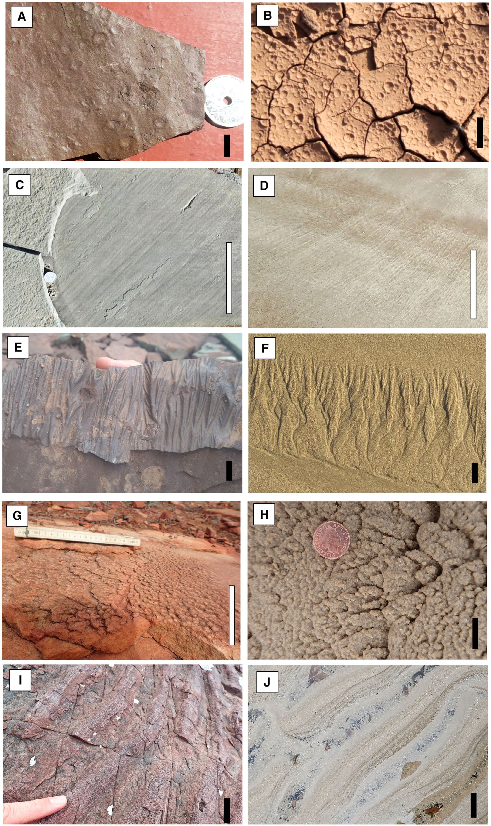
In the podcast, Neil Davies discusses a class of features in the sedimentary record that he calls “true substrates.” These are sedimentary bedding planes that demonstrably existed at the sediment-air, or sediment-water interface at the time of deposition. He asks whether true substrates are characteristic samplings of their time and place, or whether they are freak accidents that escaped destruction through exceptional circumstances, which would make them unrepresentative anomalies within a recycled and lost norm. The images here show examples of physical sedimentary structures that provide evidence for true substrates in the sedimentary stratigraphic record (on the left), with modern analogues (on the right). (A) and (B) Raindrop impressions. (A) Silurian Sundvollen Formation, Kroksund, Norway. (B) Boom River, Kyrgyzstan. (C) and (D) Parting lineation developed in plane bed flow regime. (C) Devonian Escuminiac Formation, Miguasha, Quebec, Canada. (D) Alnmouth, Northumberland, England. (E) and (F) Rill marks formed by draining water. (E) Mississippian Shepody Formation, Peck’s Point, New Brunswick, Canada (hyporelief cast of true substrate). (F) Holkham, Norfolk, England. (G) and (H) Adhesion ripples. (G) Silurian Tumblagooda Sandstone, Kalbarri, Western Australia. (H) Holkham, Norfolk, England. (I) and (J) Water-level drainage marks on ripple flanks. (I) Mesoproterozoic Meall Dearg Formation, Rubha Réidh, Scotland. (J) Alnmouth, Northumberland, England. White scale bars are 10 cm long; black scale bars are 1 cm long.
(G) and (H) from Kocurek & Fielder (1982) J. Sediment Res., 52, 1229

Examples of biological sedimentary structures providing evidence for true substrates in the stratigraphic sedimentrary record (on the left), with modern analogues (on the right). (A) and (B) Arthropod trackways crossing ripple mark crests. (A) Silurian Sundvollen Formation, Kroksund, Norway. (B) Rainy Cove, Nova Scotia, Canada. (C) and (D) Stellate form to aperture of vertical invertebrate feeding burrows. (C) Mississippian Horton Bluff Formation, Blue Beach, Nova Scotia, Canada (hyporelief cast of true substrate). (D) Hopewell Rocks, New Brunswick, Canada. (E) and (F) Reticulate marking due to tangling of biological filaments. (E) Neoproterozoic Diabaig Formation, Diabaig, Scotland. (F) Rye, Sussex, England. (G) and (H) Sand-filled impressions of stranded jellyfish. (G) Cambrian Potsdam Sandstone, Rainbow Falls, New York, USA. (H) St. Cyrus, Scotland. (I) and (J) Desiccated and dried-out microbial mat. (I) Pennsylvanian Parrsboro Formation, West Bay, Nova Scotia, Canada. (J) Stiffkey, Norfolk, England. White scale bars are 10 cm long; black scale bars are 1 cm long.
The Giant Arthropleura Fossil

The largest known arthropod in Earth history was discovered by Neil Davies and his students in January 2018, in a large fallen block of sandstone in a coast cliff at Howick Bay in Northumberland in northern England. The fossil consists of the remains of a giant Arthropleura that lived in the Serpukhovian age in the mid-Carboniferous, about 330 million years ago.

View of the fallen block (white circle) and original position (black circle) in the context of the damage zone around the Howick master fault. HT= thickening of mudrock in the hanging wall of the fault. Red arrows = sense of fault movement. Blue dashed line = approximate position of the Lickar Limestone, which marks the onset of the late Serpukhovian. Scale bar = 5 m.
Courtesy of Geospatial Research Ltd.

Above: slab A of the fossil prior to extraction. Image width is about 60 cm. Right: slab B of the fossil.


(a) Scale of the Howick Arthropleura relative to other articulated giant specimens (preserved remains highlighted in pink) and the largest arthropod trackways known from each Carboniferous-Permian stage. The previously known body fossils were both markedly smaller than the dimensions of Arthropleura revealed by trace fossil evidence. (b) Reconstruction of the Howick Arthropleura within its habitat of a lower delta plain with open woodland.
Further Reading
Davies, N.S., et. al (2021), The Devonian landscape factory: plant–sediment interactions in the Old Red Sandstone of Svalbard and the rise of vegetation as a biogeomorphic agent, Journal of the Geological Society, 178, 2929
Davies, N.S., and Shillito, A.P. (2021), True substrates: The exceptional resolution and unexceptional preservation of deep time snapshots on bedding surfaces, Sedimentology 68, 3307
Davies, N.S., et al. (2022), The largest arthropod in Earth history: insights from newly discovered Arthropleura remains (Serpukhovian Stainmore Formation, Northumberland, England), Journal of the Geological Society, 179, 2021-115