
Paul Hoffman on the Snowball Earth Hypothesis
Listen to the podcast here, or wherever you get your podcasts.
-
This transcript was generated automatically and lightly edited for readability.
Oliver Strimpel: This is Geology Bites with Oliver Strimpel. We're all familiar with the idea of ice ages, during which the polar ice caps advance to cover significant portions of their respective hemispheres and then, after a period of tens to hundreds of thousands of years, retreat back to the polar regions. But now we believe that twice during the Earth's history, the ice advanced all the way to the equator, almost completely blanketing the Earth with a sheet of ice several kilometers thick. This is the Snowball Earth hypothesis.
Paul Hoffman is Emeritus Professor of Geology at Harvard University. His research on the sedimentary rocks of Namibia, and that of his students in North America, Arctic Europe and Mongolia, uncovered compelling evidence of glaciation near the equator about 650 million years ago, in the Neoproterozoic. More than anyone else, he is responsible for synthesizing the evidence in the geological record to develop a persuasive case for a snowball Earth. Paul Hoffman, welcome to Geology Bites.
Paul Hoffman: Thanks, Oliver. I'm really pleased to be able to give a bite on Snowball.
Oliver Strimpel: What exactly do we mean when we talk about a snowball Earth?
Paul Hoffman: To a climate scientist, a snowball Earth is an Earth that's almost white, although there's a sort of gray band along the equator. It's white because the ocean is completely covered by ice, and so most of the sunlight is reflected back into space. So the air temperature is extremely cold, and the ice floating on the ocean gets very thick, on the order of a kilometer in thickness. So it flows under its own weight, like an ice shelf, and it flows towards the area where the ice is thinnest, which is at the equator. The ice is continually flowing towards the equator, and that flow is accommodated by melting at the base of the ice at the equator and freeze-on at higher latitudes, and also by the hydrologic cycle. The hydrologic cycle is weakened in the snowball case, because the air is very cold and can't hold much moisture, but there is a hydrologic cycle, and it's causing net sublimation, that's conversion of ice into water vapor, at the equator, and snowfall elsewhere.
Now, the snow accumulation rates are pretty slow because of the weak hydrologic cycle. They're millimeters to centimeters per year. That doesn't sound like very much, but the snowball episodes last for tens of millions of years, and 1 centimeter of ice accumulation every year is 10 kilometers in a million years. So you can see that over the time span of these episodes, you can have quite a throughput of ice. Now, that ice is floating on the ocean and is being sublimated at the equator, and all the volcanic ash and dust from parts of the continents that aren't ice-covered accumulates in the ice and is then exposed in the sublimation zone along the equator. So it's quite dark from the accumulation of dust and ash, and so there's meltwater production. The continents on a snowball Earth are also mostly covered by slow-moving ice sheets, but in the equatorial zone, where there's net sublimation, there's bare ground, and so it's dark and absorbs more sunlight. So those would be the warmest spots.
Oliver Strimpel: Can you give us some specifics about the timing of the snowball Earth episodes in the Earth's history?
Paul Hoffman: Well, the two pretty certain ones occurred in rapid succession. The first one began around 720 million years ago, and the second one ended at 635 million years ago. The first one is longer; the second one was shorter, and there's about a 10-million-year interlude between the two where there doesn't appear to be any ice at all. So we have these two episodes; the second one ended at 635. That's 65 million years before the first appearance of macroscopic animals in the fossil record, in the Ediacaran period, and about 95 million years before the base of the Cambrian. The first snowball, at 720, or 717 to be exact, when it started, broke an interval of almost a billion and a half years when there's no evidence of large ice sheets anywhere. Before that, there were ice ages again, and for one of those there's fragmentary evidence that it was a snowball Earth, but the evidence is very fragmentary. And of course, there hasn't been any snowball since 635.
Oliver Strimpel: So what processes, what mechanisms, could have brought about the near-total glaciation of the Earth?
Paul Hoffman: The mechanism actually arose in the very first numerical climate models, those of Budyko, and it's a persistent and robust feature of all climate models, including the most advanced coupled general circulation models. It's basically the ice-albedo feedback. It occurs because the ocean absorbs most of the solar energy that falls on it: 80 or 90 percent of the solar energy is absorbed by liquid water. But if you cover that with snow, and particularly if it's covered by ice, then only 10 or 20 percent of the energy is absorbed; most of it is reflected. As a result, if there's any climatic cooling, for whatever reason, the area of snow and ice gets larger, and so more of the sunlight is reflected rather than absorbed. So there's an additional cooling effect. That's the feedback, the ice-albedo feedback.
Now, the thing is that as the polar caps get larger, for each increment that they advance towards the equator, the area that they cover, the area that changes color, gets larger and larger, because the Earth is fatter in the middle, at the equator. And so the feedback gets stronger and stronger. What came out of these numerical models is that there is a critical point beyond which the feedback is unstoppable, and the polar caps expand until they meet at the equator. Then, because the air temperatures are so cold, the ice rapidly thickens. That instability has been known to climate scientists since the very first climate models in the mid-1960s, and it's been confirmed over and over and over again. So it's very difficult to have an ice margin in the ocean that's stable at a low latitude. They call it a bifurcation. That means you can either have no ice, which is where we've been for most of geologic history (89% of the last three billion years has had no large ice sheets anywhere); or, for 11%, there have been some large ice sheets; and then for, what, two percent of the last three billion years, there's been the snowball. So there are these three climate states. The climate modelers always assumed that the snowball had never happened, so they never talked to geologists. And the geologists had a lot of evidence, but they didn't know what to make of it, so they put it in a drawer.
Oliver Strimpel: So if we had this runaway glaciation, why didn't the snowball Earth last forever?
Paul Hoffman: Well, of course, the climate physicists thought that it would; that's why they assumed it had never happened, because if it had happened, we wouldn't be here. But then a trio of planetary physicists at the University of Michigan thought about why the Earth's climate is stable over billions of years, despite the fact that the sun is getting brighter and brighter, and they worked it out. It was because of the silicate weathering feedback, which is a negative feedback; the ice-albedo feedback is a positive feedback. The way it works is that if it gets colder for any reason, then the rate of weathering, and the rate of drawdown of CO2, goes down. As a result, the CO2 that's coming out of volcanoes builds up, and that prevents any further cooling. It stabilizes the climate. It allows climate change, but it stops it from going into runaway warming or runaway cooling.
And so what they realized is that if the Earth did go into a snowball, you couldn't get the CO2 out of the atmosphere, because CO2 is only soluble in liquid rain, not in snow. But on the snowball, CO2 would continue to come out of volcanoes, and so carbon dioxide would accumulate in the atmosphere. And because you would need a hundredfold, or several-hundredfold, increase in carbon dioxide concentration, it would take a long time for the carbon dioxide to build up and make a strong enough greenhouse effect to overcome the white Earth's albedo. But when it reached that critical level of carbon dioxide, it would start to melt. And when it starts to melt, you're replacing white ice with dark water, so that same ice-albedo feedback works in reverse, and the whole thing melts down extremely rapidly, in a thousand, two thousand years, maybe. And then you have the hottest climate the Earth has ever experienced, because you have this huge amount of carbon dioxide but a dark surface, and it takes quite a long time, 10 million years or so, to draw down that carbon dioxide through weathering.
Oliver Strimpel: This might be a naive question, but if the Earth is covered by several kilometers of ice, how does the outgassing from the volcanoes, how does the CO2, get into the atmosphere?
Paul Hoffman: The most CO2-rich volcanoes are the stratovolcanoes that stand up quite high, and they aren't completely buried by an ice sheet. At the summits, where the outgassing mainly occurs, the ice is fairly thin. And moreover, we know from Iceland that there are volcanoes that erupt under an ice cap or underneath an ice sheet, and it only takes a few weeks once the eruption starts for the melting to make a pipe through the ice, as any European commercial airline pilot can tell you. And also, of course, there's a lot of CO2 coming out of mid-ocean ridge volcanoes. That CO2 goes directly into the ocean, but it leaks out into the atmosphere through cracks, because the marine ice floating on the ocean is flowing, and so there are always cracks developing, particularly along coastlines, where the floating, moving ice abuts against land-fast ice. So there's shearing there, and continual cracks developing, and air-sea gas exchange is pretty rapid. So the ocean and atmosphere would probably be in equilibrium, on the snowball time scale, with respect to CO2.
Seafloor weathering does occur a little bit, pretty slowly because of the very cold temperatures, but as CO2 builds up, the seawater gets more acidic, and seafloor weathering, which consumes carbon dioxide, becomes a little stronger. So the CO2 rise is nonlinear, and that could help to explain why the two snowballs are quite different in duration. Because of the nonlinear CO2 rise, you could get quite a long time difference to get to the same CO2 level if the conditions were slightly different.
Oliver Strimpel: OK, let's start talking about the evidence for snowball Earth in the geological record. Ice ages have been documented extensively in the geological record. Indeed, there's a whole geological period called the Cryogenian, which is named after the very cold climate and ice ages thought to have prevailed then. So what was it that led us to suspect that ice once covered the entire globe?
Paul Hoffman: Well, the Cryogenian is the period of the two snowballs. There are basically three lines of evidence. The first was that the glacial deposits are very widespread. They're present on all continents, and they occur in the sediments not too far below the Cambrian. We didn't know exactly that they were the same age, but it's been known since the early 1930s that glacial deposits of this age are widespread on every continent, more widespread than for any other ice age. So that was the first line of evidence. The second one, and the one that particularly attracted me to the problem, was that you find glacial deposits that are conformably interbedded with thick marine platform carbonate successions. And then the third was paleomagnetic evidence that the glaciers, the ice sheets, formed very close to the equator.
Oliver Strimpel: So how can we tell if a deposit has a glacial origin?
Paul Hoffman: They're very similar to deposits of the last ice age. You find tills. Till is an old Scottish farmers' term for a stiff clay confusedly mixed with boulders. That's how it was originally defined, by James Smith in 1836. The reason it's stiff is because it's had a glacier sitting on it. And the boulders are of a wide variety of derivation, often from afar, and they're often rounded and highly smoothed and polished by the action of the glacier, the milling that goes on underneath the glacier. Also, many of the boulders are faceted and striated, scratched in various directions because of the glacial action. There are massive tills and stratified tills. The stratified tills, which are deposited under water, beneath floating ice in front of the grounding line of a tidewater glacier, are peppered with dropstones. These dropstones melt out of a floating ice shelf or icebergs, sink through the water column, impact the bottom, and leave these beautiful little miniature impact structures. You can see millions of dropstones in a given outcrop. So these Cryogenian deposits look the same as the younger ones; it's just that they're more widespread, and they're often composed entirely of carbonate, because the glaciers were running on carbonate platforms.
Which brings us to the second point: carbonate platforms. What are these? If you remember, the first success of Charles Darwin as a scientist was his theory of coral reefs and atolls. What he pointed out was that seamounts, or islands and whatnot, in the tropical oceans have coral reefs that grow on them, and they produce a lot of carbonate and carbonate debris. If the volcanic mountain, or the island, or whatever it is, is slowly sinking, the coral, which grows rapidly when it's in the sunlit surface ocean, keeps pace with the subsidence, and you build up this pedestal of carbonate, which has a flat top because it's at sea level. These pedestals can be very large, like the Great Bahama Bank, which is hundreds of kilometers in diameter. They can also border coastlines, like the Yucatán shelf in Mexico.
Now, what Darwin pointed out is that these only form in the tropical ocean, at latitudes less than 35 degrees. The reason for that is the basic saturation chemistry of calcium carbonate. It's a peculiar salt: it's more soluble in cold water than in warm water. Carbonate alkalinity is coming into the ocean from weathering, and stuff that comes in has to go out. The carbonate preferentially forms in the warmest part of the surface ocean. Carbonate is more soluble at depth because of the pressure effect, so it's in the warmest part of the surface ocean that carbonate accumulates. So I said to myself, if there are glacial deposits on carbonate platforms, which are at sea level in the warmest part of the ocean, and there are no mountains from which glaciers could descend from frigid heights, then if there are glaciers there, all the colder parts of the world have to be frozen as well. That was one of the reasons I went to Namibia: to make sure that the glacial deposits are pretty conformable with the carbonates, that there are no big gaps in the stratigraphic record that could allow large changes in latitude, for example. I spent five years in Namibia proving to myself that, no, it's pretty much a stratigraphic continuum.
And the third is the paleomagnetic evidence. Basically, if you can recognize and prove that the remanent magnetization in the rock originated at the time the rock formed, then you can tell the latitude, because the magnetic lines of force at the equator are basically horizontal, and at the pole they're vertical. So there's a simple mathematical relationship between the inclination of the magnetic lines of force and the latitude. And what was found in Australia, and also in North America, was that the glacial deposits formed very close to the paleoequator.
Oliver Strimpel: So you discussed the carbonate platforms interleaved with the glacial deposits as evidence of glaciation at sea level in the tropics. But there's also key evidence from a different type of carbonate deposit that overlies the glacial deposits, the so-called cap carbonates.
Paul Hoffman: Cap carbonates, which are unique to Cryogenian glaciations. They're called caps because they lie directly on top of the last glacial deposits. You can recognize the deglaciation, and immediately on top there are these very distinctive layers of carbonate, either dolomite or limestone. They can be anywhere from meters to hundreds of meters thick, and they occur virtually everywhere, at all latitudes. First of all, carbonates don't do that. Carbonates are normally at low latitudes, particularly non-skeletal carbonates. But these are everywhere, and they have a lot of structures and textures and compositional aspects that say that the water they precipitated from was hugely oversaturated, which is a very unusual situation, because the degree of oversaturation of seawater is normally limited by carbonate production. So I was fascinated by cap carbonates. And at first it seemed that they ran counter to the snowball hypothesis. The snowball hypothesis implies very high carbon dioxide concentrations towards the end and in the aftermath, and carbon dioxide is an acid. It makes carbonate dissolve, not precipitate; it lowers the saturation state. So what's going on here?
That's when my colleague Dan Schrag, a geochemical oceanographer, figured out the explanation for cap carbonates. It's called buffering; that's the chemical term for it. When you have acid indigestion, you take tablets, and those tablets used to be called buffers. It was a very good name for them, because those tablets are just calcium carbonate, limestone ground up into a fine powder. If you chew up and swallow a whole bunch of those tablets, after a while you start to feel better. What's going on in your stomach is that the calcium carbonate is dissolving, and that dissolution reduces the acidity. It's exactly the same in the snowball ocean. When it starts to get acidified because of carbonic acid, the tablets, which are all the carbonate rock flour that the glaciers are delivering into the ocean, dissolve, and that dissolution prevents the ocean from getting too acidic. It also maintains the saturation state of the ocean, so it's always poised to precipitate carbonate again if conditions should change.
Now, over the range of carbon dioxide values that you need to deglaciate a snowball Earth, the amount of carbonate that goes into solution in the ocean is sufficient to cover the entire continental surface area of the Earth with 4 meters of carbonate. As soon as the snowball melts down, the ocean rapidly warms up, so that's driving up the carbonate saturation, and the continents get flooded and CO2 starts to get drawn down. So all that dissolved carbonate has to come back out again, and that's the cap carbonate. And it has the same carbon isotopic composition as the youngest pre-glacial rocks, because it's the same carbonate; the carbon isotopes don't change, because it's just recycled. So for me, the fact that the snowball explained the cap carbonates (in fact, they became a prediction rather than a paradox) was when I really started to take this very seriously.
Oliver Strimpel: OK, so at the end of the snowball, the oceans warm and carbon dioxide levels diminish, and the oceans re-equilibrate, causing the dissolved carbonate, which had acted as a naturally induced pH buffer, to precipitate out to form the cap carbonates. And those cap carbonates would have been global, not just limited to the tropics, right?
Paul Hoffman: Yeah, it's very unusual. I mean, the Ediacaran period is defined at the end of the last snowball because everyone can recognize the cap carbonate everywhere. And there's not been a single complaint about that choice as the golden spike for the Ediacaran period. It works perfectly.
Oliver Strimpel: Are there any other lines of evidence for the snowball Earth hypothesis?
Paul Hoffman: Yeah, there's one that's emerging, and I think it's really fascinating, and I expect in the end it'll be one of the most persuasive ones, and that's the gene sequences in modern organisms. One of the things that's emerged comes from what's called ancestral state reconstruction, which is statistical correlation between gene sequences and habitat: freshwater, saltwater, warm, cold, et cetera. Then you map those correlations onto phylogenetic trees that you get from molecular clocks, which also come from gene sequencing. One of the controversial things that has been emerging is that most primary producers, these are photosynthetic organisms, cyanobacteria and the ancient algae, the red and the green and the chromophyte algae, and their descendants, all land plants, appear to have evolved over most of their evolutionary history in freshwater, and only in the last six or seven hundred million years, roughly speaking, have they radiated into marine environments.
Now, paleontologists said this is completely ridiculous, because we have a fossil record of cyanobacteria that look a lot like modern ones going back over 2 billion years, and we have a fossil record of multicellular red and green algae going back over 1 billion years, long before the snowball. So it's complete nonsense. Well, they're both right. The point is that all living things are descended from the snowball survivors. So of course there were algae and cyanobacteria in the oceans, but when the lights went out, they mostly didn't survive. So who survived? Because the snowball comes on very rapidly, evolution can't keep pace, so it's got to be those that were pre-adapted. And who's pre-adapted? Well, of course, it's the polar-alpine organisms that have been living on glaciers and beside glaciers all along. For them it's a field day, because suddenly their habitat greatly expands. It's at the equator, so they don't have to deal with the polar winters. So they expand. They occupy all that dusty habitat, where there's meltwater in brilliant sunlight, and lakes on the land, which are very rich in nutrients. But the biggest of those polar-alpine habitats are the meltwater-based habitats, which of course are fresh water.
Today, if you look at those habitats, they have cyanobacteria, they have green algae, they have fungi, they have heterotrophic protists, they even have some metazoans. And so all the organisms that were occupying those habitats in the equatorial zone, when the snowball melted down, all got flooded. They all ended up in the ocean, an ocean that was charged with nutrients because of no productivity, and warming rapidly. And so they radiated. So the paleontology and the molecular biology are both right, and they're telling a great story: that we, and everything else, came from the survivors of snowball Earth. So it was a very important filter. And if it's true, the evidence is going to become abundantly clear when people get onto how to interpret it in the record of living organisms, because of the amount of data that is in the sequences of base pairs in organic molecules. I mean, this is why it's been the dominant science for the last 60 years, and in all likelihood will be for the next 60 years.
Oliver Strimpel: Aren't we also partially descended from the archaea? And couldn't the archaea survive when the lights went out, because they didn't depend on the light?
Paul Hoffman: Sure, of course. By survivors, I mean all survivors. There's subsurface life, all of which may not even have known a snowball occurred. But primary production is mainly from photosynthesis. There's a surprising biomass in the hot, deep biosphere, but its turnover rate probably isn't too great. But I'm not excluding that.
Oliver Strimpel: So you described how there's a positive feedback loop that leads to a runaway glaciation. But why could this have happened only twice in history? In fact, why didn't every ice age lead to a snowball?
Paul Hoffman: Well, it's the negative feedback from the temperature dependence of silicate weathering that stabilizes climate and gives us our habitable planet, and that also tends to limit the climatic excursions; in most cases it prevented a snowball. It's a very potent negative feedback, but it's ponderously slow. It operates on a time scale of a hundred thousand to a million years, and so if you do something fast, you can beat it. And so the trick is to have a cold climate to begin with, because that makes it closer to the point of instability. There was a climate model published nearly 20 years ago that came to the conclusion that if the K-T impact occurred today, it would produce a snowball. That's because the ocean in the Cretaceous was 10 to 12 degrees, whole-ocean mean temperature, whereas today it's about one and a half degrees, so it's a lot easier to freeze it over. And with an impact, you get not much sunlight for a decade or so, until all the dust and whatnot settles. So you don't have a lot of time.
So to get a snowball, which is a rare phenomenon, you need either a rare event or a rare combination of events. And I think the most sensible way is to think, well, it's most likely to occur at a time when the climate is fairly cold to begin with. A lot of people think that the Cryogenian should have been a generally cool period, because of the breakup of the Rodinia supercontinent, which should increase both weathering and carbon burial. So it makes sense that you would have a stable climate, but with lower CO2 and a cool climate relative to the long-term norm.
Now, something rare had to happen, and for the first snowball, it's pretty clear from the coincidence that it was an enormous outpouring of lava, which is now in Arctic Canada, all the way from Yukon to Greenland, that occurred 719 million years ago. At that time, it was right on the equator; we know that because of robust paleomagnetic data from those lavas. Also, those lavas are very rich in sulfur, and that's because they came up through a sequence that is rich in sulfate evaporites. So you've got an unusual combination. You have a very large igneous province (there are a lot of those), but it was right on the equator, and it's rich in sulfur. That means if you had very thick lava flows, you had a thermal plume, like you see in Iceland, that's capable of injecting sulfate aerosol into the stratosphere. And that's geoengineering; that makes the climate cool. That's what we're going to do about global warming anyway.
Now, here's where the cold climate helps, because if the climate is cold, the stratosphere becomes lower. That's why Icelandic volcanoes have a significant climatic effect: the base of the stratosphere, the tropopause, is very low at high latitudes; it's much higher in the tropics. But in a cold climate it comes down a little bit. So you have this combination of things: a large igneous province, very rich in sulfur, right on the equator, maybe in an already cold climate. Maybe that was what broke through on a short time scale, faster than the silicate weathering feedback could moderate. But there's a counter-theory, and that is that these lavas, being right on the equator, weathered extremely rapidly, and that weathering pulled down CO2. And because it was right on the equator, the silicate weathering feedback wouldn't be very effective, because it's always hot there, and there's also a lot of rainfall. So there are two competing theories, but both are linked to the Sturtian and to this event.
Oliver Strimpel: Just to explain, the K-T impact you mentioned a few minutes ago is the asteroid impact thought to have caused the mass extinction, including that of the dinosaurs, which marked the end of the Cretaceous period 66 million years ago. And the Sturtian and Marinoan are the names of the first and second snowball glaciations.
Paul Hoffman: Here's the problem. No such event is known before the Marinoan. It's possible there is a big igneous event on the south margin of the Qinling orogen, which separates South China and North China, but it's all deformed and not really precisely dated, and it's hard to know its original extent. So we don't really have an evident trigger for the second snowball. And the fact that they occurred in rapid succession suggests that it wasn't just this event; it was something about the ambient conditions at that time. So the why question is still out there. We don't have a fully satisfactory explanation.
Oliver Strimpel: It seems as if a runaway warming process happened on Venus, which has been a baking inferno ever since. What's different about Venus that prevented it from restoring more moderate conditions, as we have on Earth?
Paul Hoffman: Well, first of all, the Venus atmosphere is 100 times more massive than the Earth's atmosphere, and it's mainly composed of carbon dioxide, with a little bit of sulfur dioxide, and they're both greenhouse gases. The Earth's atmosphere is mostly nitrogen and oxygen, neither of which is a greenhouse gas. But what we don't know about Venus (I'm not an expert on this, but my impression is that it's still not clear) is whether the difference in the Venusian atmosphere comes from the way the atmosphere was acquired to begin with. There's a lot of uncertainty about how planets acquire atmospheres. The primary atmosphere should have all been stripped away during the T Tauri phase of early stellar evolution. So the general thinking is that the atmosphere is secondary, and was either acquired or came from outgassing from the magma ocean, and the details of the chemistry of the magma ocean apparently significantly impact the composition of the atmosphere. So we don't know whether the difference between Venus and Earth is, on the one hand, a difference in the composition of the atmosphere from the start, or whether it's a different trajectory over geologic time, because Venus is closer to the sun, and the sun, of course, is brightening all the time. So Venus is ahead of us.
Oliver Strimpel: How was the idea of the snowball Earth received by the geological research community when it was first proposed in 1989?
Paul Hoffman: Incredulity and disbelief. My friends thought I was going to ruin a good reputation, and a lot of other people thought that I was making a mockery of the discipline.
Oliver Strimpel: But the pendulum has swung the other way now. What convinced people?
Paul Hoffman: Well, you remember what Max Planck said: science advances one funeral at a time. True, it has changed, but it's been generational change. Most of the currently active workers are now on board with the snowball, and generally they're satisfied with the evidence. The reason for the change depends on the discipline. The climate people are convinced because of the robustness of the ice-albedo instability, or bifurcation, as they call it. The geochemists are more convinced by the evidence from the cap carbonates, including isotopic evidence, direct evidence for high CO2 from triple oxygen isotopes and other fancy things like that. Geologists, I think, were most convinced by the demonstration, through radiometric dating, both uranium-lead and rhenium-osmium, that both snowballs glaciated simultaneously on many different continents, within the resolution of the dating, less than half a million years or so, and according to some geochemical arguments, even on a time scale much less than that. And biologists probably haven't decided yet. That will probably come mostly from the evidence from molecular biology, and also from a better understanding of the diversity of polar-alpine ecosystems. That will still be a big help.
Oliver Strimpel: When were you personally convinced that the snowball Earth was real?
Paul Hoffman: I was convinced that it needed to be taken very seriously when Dan Schrag explained the cap carbonates to me. So it was kind of stepwise, but before I published my first paper on it, I was pretty convinced. I never expected to see people accept it in my lifetime.
Oliver Strimpel: Paul Hoffman, thank you very much.
Paul Hoffman: It's been a pleasure, Oliver.
Oliver Strimpel: For more about Geology Bites, as well as pictures and illustrations that support this podcast, you can go to geologybites.com.

Paul Hoffman is Emeritus Professor of Geology at Harvard University. His research on the sedimentary rocks of Namibia revealed compelling evidence of glaciation at sea level in the tropics about 650 million years ago. In the podcast he explains what convinced him that the Earth was almost completely glaciated twice in its history. Here, Paul Hoffman (right) and Dan Schrag point to the contact between the end-snowball glacial deposits with dropstones and the 635-million-year-old dolomite that caps the glacial deposits in Namibia. Dan Schrag is a geochemical oceanographer who reconciled the cap carbonates with the Snowball Earth hypothesis.
Courtesy of Gabrielle Walker
Podcast Illustrations
All illustrations courtesy of Paul Hoffman unless otherwise indicated.
Snowball Earth

The Snowball Earth is a climate state in which the oceans are covered by a continuous ice shelf and continents are mostly buried by ice sheets. In the ablation zone, ice sublimates directly into the atmosphere. Dust or volcanic ash accumulate on the glacier as dark ice-dust (called cryoconite).
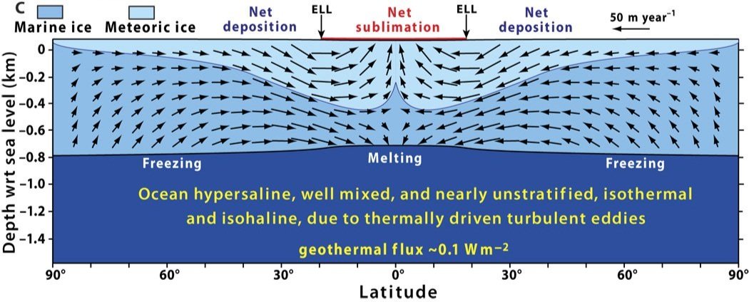
Sea glacier on a Snowball planet with a sublimation zone (in red) where dark ice-dust collects and a layer of compressed snow (meteoric ice) accumulates. Sublimation of meteoric ice and melting of marine ice at low latitudes are balanced by an accumulation and freeze-on outside the inner tropics. At the ELL (Equilibrium Line Latitude) the sublimation and deposition are equal.

Glacial epochs in Earth history from 3.5 billion years ago to the present day. The Sturtian and the Marinoan are the only two periods in which the ice sheets extended from pole to pole.
The Geochemical Carbon Cycle and Global Climatic Stability
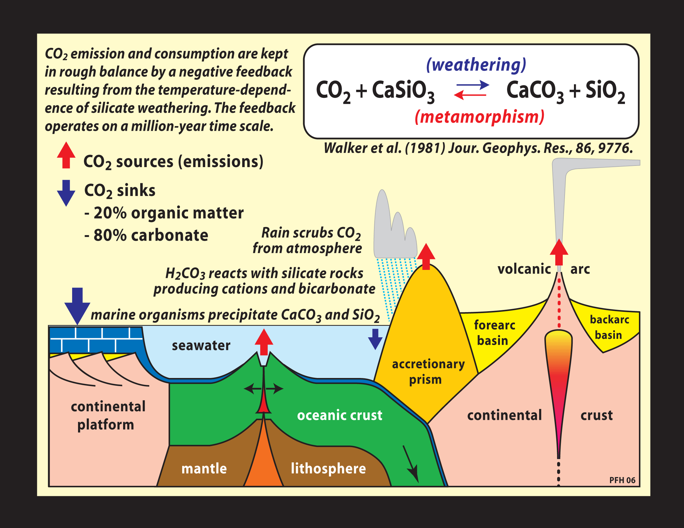
The geochemical carbon cycle, showing major sources and sinks of carbon dioxide to the ocean and atmosphere. As carbon dioxide accumulates and the planet warms, the weathering of rocks containing silicate minerals increases, which increases the rate of removal of carbon dioxide from the atmosphere, which counteracts the warming. This negative feedback adjusts the amount of carbon dioxide in the atmosphere so as to balance the carbon dioxide sources and sinks, maintaining a steady state.

The geochemical cycle on a Snowball Earth. Volcanic and metamorphic carbon dioxide sources continue unaffected, but removal of carbon dioxide from the atmosphere is limited by the absence of rainfall. In addition, silicate weathering is reduced by ice cover and cold ground temperatures.

Hypothetical depiction of the Sturtian Snowball Earth scenario in terms of global mean surface temperature and ice cover (pale blue) on the Earth with the continents of 750 million years ago. The temperature plot shows that the onset (purple dot) and termination (blue dot) of glaciation near the equator were very abrupt. It also shows a hot aftermath caused by high carbon dioxide levels.
The Evidence for a Snowball Earth

Global Distribution
The present global distribution of Cryogenian glacial formations corresponding to the Marinoan glaciation (651-635 million years ago) and the Sturtian glaciation (717-661 million years ago).

Distinctive Glacial Features
Tillite deposited by the Marinoan glaciation with rounded and polished boulders dispersed in an unstratified silty claystone matrix. Glaciers erode by abrasion and quarrying, and deposit unsorted debris when they melt or sublime. As the glacier flows, boulders are rounded and polished by milling caused by shearing of the substrate below the glacier and the sediment carried by the ice. Hammer (circled) is 32 cm long.
Moonight Valley Tillite (Marinoan), East Kimberley Region, Western Australia

Grooves in a sandstone were produced by northwest-directed (arrow) glacial flow. This glacial pavement is overlain by a moraine composed of glacial till (upper right), onlapped and buried by shallow-marine clastics, implying a former tidewater ice margin or grounding line.
Smalfjord Formation (Marinoan), Bigganjar’ga, Varangerfjord, Finnmark, NE Norway

The diagram shows how a distinctive wedge of sediment is deposited at a grounding line, which is where a grounded ice sheet becomes a floating ice shelf. Massive diamictite (a sedimentary rock with a wide range of particle sizes) is deposited on the landward side of the grounding line (brown), and a stratified diamictite is deposited on the seaward side of the grounding line (orange). The stratified diamictite combines material falling out of a plume of meltwater, ice-rafted debris, and deposits from density flows and bottom currents.

An ice-rafted dropstone impacted the underlying stratified deposits (carbonate turbidites, debrites and plume fallout), which were punctured and deformed by the impact. Below the 2-cm coin (top right) is a doubly-folded sediment flap that was ejected by the impact site. Ice-rafting is a key criterion for glacial action in marine paleoenvironments.
Ghaub Formation (Marinoan), Fransfontein Ridge, NW Namibia

A graded debrite (debris-flow deposit) in the proglacial sediments deposited within a Marinoan grounding-zone wedge in northern Namibia. Coarse debris flows can be triggered by excess debris pile-up at the ice grounding line and by oscillatory movement of the grounding-line ice-front itself.
Ghaub Formation (Marinoan), Fransfontein Ridge, NW Namibia

Carbonate Platforms
Distribution of recent marine carbonate reefs, platforms (e.g., Great Bahama Bank), and continental shelves. Most marine carbonate production occurs in shallow waters and latitudes less than ~35° because of carbonate saturation chemistry. Calcium carbonate is more soluble in colder and deeper water than in warm, shallow water. Certain organisms precipitate skeletal carbonate in colder, deeper water by controlling carbonate saturation in intracellular fluid, but skeletal carbonate is absent in Cryogenian deposits. On tropical coasts near major deltas (e.g., Amazon, Congo), carbonate production is inhibited or diluted by terrigenous sediment input.
Modified after Rodgers (1957) in Le Blanc RJ et al. eds., Regional Aspects of Carbonate Deposition. Sp. Publ. 5, SEPM (Society for Sedimentary Research)

The strata underlying the glacial deposits represent ambient ocean conditions at or close to the time of glacial onset. The figure shows carbonates underlying glacial deposits in several locations (e.g., North and South Namibia), which provide evidence of glaciation at sea level in the tropics. In other locations, the glaciers formed at mid-latitudes where carbonate is uncommon, or were formed in the tropics but near deltas where carbonate production was swamped by detritus from land erosion (terrigenous), such as in the present-day Amazon or Congo River deltas.

Generalized stratigraphy and rock types of carbonate-dominated platform successions of Neoproterozoic age in northern Namibia and western Mongolia. Glaciomarine formations and postglacial cap carbonates of Sturtian and Marinoan age are well developed and exposed in both areas. They indicate glaciation at sea level in the warmest zones and in the absence of mountains. If the warmest areas were glaciated, colder areas must have been frozen as well. This was the rationale for the Cryogenian Snowball Earth hypothesis (Kirschvink 1992).

The Rapitan Group (716-663 million years old) is a glacial sequence sandwiched between carbonate units in the Mackenzie Mountains of northwest Canada. The rocks get younger from right to left.

The Marinoan Wilsonbreen Formation (W) in Spitsbergen (Svalbard) is a 135-meter-thick glacial sequence bracketed by carbonate units (S and D). The much more recent Carboniferous-Permian limestone (CP) is visible in the far distance.

Paleomagnetic Evidence
The right side of the figure shows how the inclination of the magnetic field frozen into a rock at the time it formed tells us its latitude at that time (paleolatitude).
The left side of the figure shows histograms of the paleolatitudes of glacial deposits for various periods of geological history. It indicates that in the Neoproterozoic there was an anomalously high number of glacial deposits in equatorial regions.

Glacial Meltdowns and the Cap Carbonates
Contact between the younger (Marinoan) Cryogenian cap carbonate (CD) that overlies ice-rafted debris (IRD) and glacial debris flows (DF) in Namibia.

Marinoan cap carbonate (dolostone) and underlying Stelfox glacial diamictite in the northwestern Mackenzie Mountains, Northwest Territories, Canada. The Stelfox diamictite is ~40 m thick and disconformably overlies a carbonate-dominated marine shelf sequence (Keele Fm). The cap dolostone is 12 m thick and is conformably overlain by deeper-water marls (Hayhook Fm) and organic-rich black shale (Sheepbed Fm) that yielded a radiometric age of 632 Ma. The pale color of Marinoan cap dolostones is globally distinctive, and those in the Mackenzie Mountains feature giant wave ripples indicating enhanced trade winds during snowball deglaciation.

10-m-thick cap dolostone conformably overlies the Marinoan Storeelv diamictite-rich formation in Tillite Canyon on Kap Weber near the head of Keiser Franz Joseph Fjord, central East Greenland. The cap dolostone is conformably overlain by deeper-water multicolored argillite and marlstone (Canyon Fm) of the postglacial maximum flooding stage. The base of the cap dolostone defines the Cryogenian−Ediacaran boundary. Glacial deposits were first recognized and described at this location by Christian Poulsen during Lauge Koch’s first ship-based expedition to East Greenland in 1929.

Post-Marinoan cap-carbonate sequence on the Otavi/Swakop Group carbonate platform in NW Namibia. The anomalous thickness of cap-carbonate sequences in many areas was an early indication of glacial longevity before radiometric ages were available.
Maieberg Formation (early Ediacaran), upper Hoanib River, NW Namibia
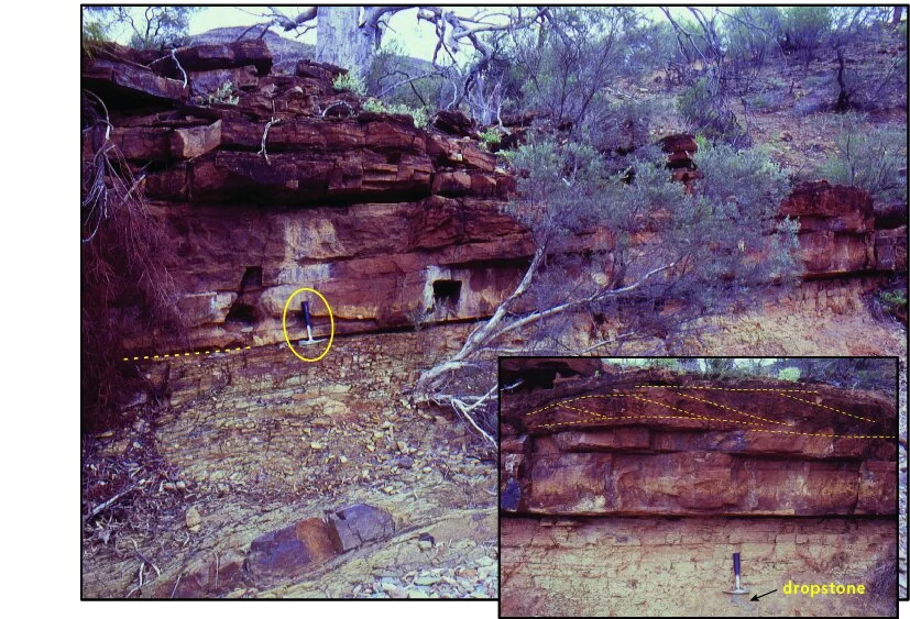
An unusually well-developed post-Sturtian cap dolostone sharply overlies the terminal siltstone of a Sturtian tillite. The siltstone contains ice-rafted dropstones (inset). In this area, the post-Sturtian cap dolostone is better developed than its post-Marinoan equivalent.
Tapley Hill Formation (Cryogenian), Kingsmill Creek, Arkaroola Wilderness Sanctuary, northern Flinders Ranges, South Australia

Phylogenetic Evidence
The time scales of fossil records over three eons. Though most of the pre-snowball fossil cyanobacteria are found in marine formations, the mapping of habitats onto molecular phylogenies indicates that they originally evolved in freshwater habitats before Cryogenian time. pO2 = partial pressure of oxygen in the atmosphere.

An example of habitat mapping onto a phylogenetic tree for living cyanobacteria and archaeplastida (red, green, and glaucophyte algae, and derived plants). Orange and blue dots on the branching points give the relative proportions of freshwater and marine correlates respectively. The dots are mostly orange (freshwater) before the Cryogenian snowballs.
Sanchez-Baracaldo et al. (2017), PNAS 114, E7737

Table summarizing polar-alpine habitat diversity for phototrophs (organisms that obtain their energy from sunlight) in terms of temperature, sunlight intensity, nutrient availability, and redox state. The salt-stratified (meromictic) lake habitat refers to deep waters (over 40 m) that have dim light but are warm (+24 C in Antarctica) and relatively relatively nutrient-rich.
Why Were There Just Two Snowball Earth Glaciations?

Rifting Rodinia
Reconstruction of the Rodinia supercontinent at 720 (bottom) and 635 (top) million years ago. The presence of a supercontinent at equatorial latitudes and its subsequent break-up may have brought higher precipitation to previously arid regions, increasing silicate weathering, and thus drawing down atmospheric carbon dioxide, which in turn would have cooled the Earth.
Large Igneous Province
The 720 Ma reconstruction also shows the large igneous province (Franklin LIP) that erupted at the equator at the start of the Sturtian glaciation. According to one theory, the magma erupted through sulphur-rich deposits, lofting sun-reflecting sulphur particles into the stratosphere, which increased the Earth’s albedo. According to another theory, the large area of freshly exposed lava at equatorial latitudes increased silicate weathering, drawing down atmospheric carbon dioxide. Either mechanism would cause cooling. Glaciation that is rapid enough to overcome the geochemical carbon negative feedback is easier to envisage if the Earth is already cool when the glaciation begins.
Further Reading
Abbot, D.S., Voigt, A., Li Dawei, Le Hir, G., Pierrehumbert, R.T., Branson, M., Pollard, D. & Koll, D.D.B. (2013) Robust elements of Snowball Earth atmospheric circulation and oases for life. Journal of Geophysical Research: Atmospheres 118, 6017−6027.
Budyko, M.I. (1969) The effect of solar radiation variations on the climate of the Earth. Tellus 21, 611−619.
Goddéris, Y., Le Hir, G. & Donnadieu, Y. (2011) Modelling the snowball Earth. In: Arnaud, E., Halverson G.P. & Shields-Zhou, G. (eds) The Geological Record of Neoproterozoic Glaciations. Geological Society, London, Memoir 36, pp. 151−161.
Harland, W.B. & Rudwick, M.J.S. (1964) The great infra-Cambrian ice age. Scientific American 211(2), 28−36.
Hoffman, P.F. (2009) Pan-glacial—a third state in the climate system. Geology Today 25, 107−114.
Hoffman, P.F. & Schrag, D.P. (2002) The snowball Earth hypothesis: testing the limits of global change. Terra Nova 14, 129−155.
Kirschvink, J.L. (1992) Late Proterozoic low-latitude glaciation: the snowball Earth. In: Schopf, J.W. & Klein, C. (eds) The Proterozoic Biosphere. Cambridge University Press, Cambridge, UK, pp. 51−52.
Pierrehumbert, R.T., Abbot, D.S., Voigt, A. & Koll, D. (2011) Climate of the Neoproterozoic. Annual Reviews of Earth and Planetary Sciences 39, 417−460.
Rooney, A.D., Strauss, J.V., Brandon, A.D. & Macdonald, F.A. (2015) A Cryogenian chronology: Two long-lasting synchronous Neoproterozoic glaciations. Geology 43, 459−462.
Sellers, W.D. (1969) A global climatic model based on the energy balance of the Earth–atmosphere system. Journal of Applied Meteorology 8, 392−400.
Vincent, W.F., Gibson, J.A.E., Pienitz, R., Villeneuve, V., Broady, P.A., Hamilton, P.B. & Howard-Williams, C. (2000) Ice shelf microbial ecosystems in the High Arctic and implications for life on snowball Earth. Naturwissenschaften 87, 137−141.